One of the exciting new changes in MAPublisher 8.3 is that we’ve substantially rewritten our reprojection engine. What I’d like to do here is explain what the changes are, and what they mean for you, the user.
The old reprojection engine was point-by-point. Essentially, we walked each path and simply reprojected each point one by one. This simple approach works very well but it has one important deficiency: it lacks context. The internal reprojection system never sees anything more than a single point, and therefore is limited to just reprojecting.
So what is the new system doing? Our new reprojection engine is performed feature-by-feature. This is important because it means the internal system no longer just sees a single point, but rather a collection of points and how they are arranged. This means it can notice things like an area that wraps around to the other side of the world! In the old system, it would just blindly punch out points, and if a path suddenly jumped to the other side of the page, well, that’s where the path went. But now the reprojection engine can notice things like that, and clip the art appropriately. If necessary, it will even break a single path into a compound path! But it’s probably easier to understand if we demonstrate it visually.
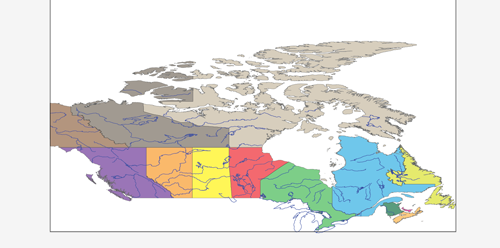
Here is a map of Canada with two layers: rivers & provinces. Both sets of art are coloured nicely and the provinces layer even has an opacity reduction to make the rivers stand out a little.

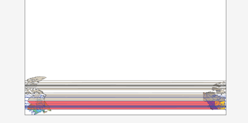
I’ve created a new coordinate system I’ve called ‘Miller Cylindrical Shifted’. I just made a copy of the ‘Miller Cylindrical’ coordinate system and then altered my copy’s central meridian to be 90 instead of zero. I did this so that if I reproject Canada into ‘Miller Cylindrical Shifted’, half of Canada should be on the left-hand side, and half should be on the right-hand side. Let’s see how MAPublisher 8.2 handles it:

Yikes! The old reprojection engine had no idea that some of those lines were going off the end of the projection’s envelope!
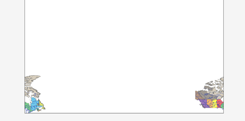
Now let’s try it in MAPublisher 8.3 with the new reprojection engine:

Wow! What a difference feature-by-feature makes! The new engine recognizes that those paths needed to be clipped and properly split polygons and lines as needed. It’s also important to note that the areas & lines are still intact. e.g. Northwest Territories was split, but it’s still a single compound path with all of its islands — some of those islands have simply been split into pieces. The split even preserves all the original path’s properties, including attributes and styles!


