My Account     Contact Us     Cart

Articles

Avenza Releases MAPublisher 10.7 For Adobe Illustrator

Toronto, ON, December 14, 2020 – Avenza Systems Inc., producers of the Avenza Maps® app for mobile devices and geospatial plug-ins for Adobe Creative Cloud, including Geographic Imager® for Adobe Photoshop®, is pleased to announce the release of MAPublisher® 10.7 for Adobe Illustrator®.

This MAPublisher release improves on continued compatibility with Adobe Illustrator 2021 and macOS Big Sur. Product licensing improvements include a new Cloud floating license for easier setup for both admin and end-users. “Over the past several quarters, we have geared ourselves up for some major enhancements and have been working closely with our product partners at Adobe,” said Ted Florence, President of Avenza. “We’ve learned a lot and are continuously exploring more product features in the latest Adobe releases to bring them to our community of mapping professionals.”

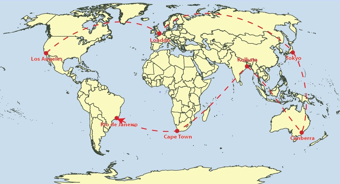
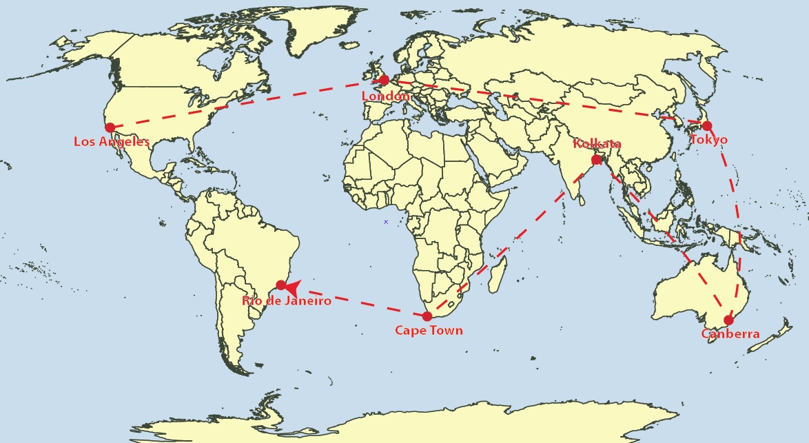
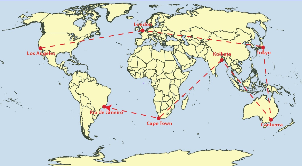
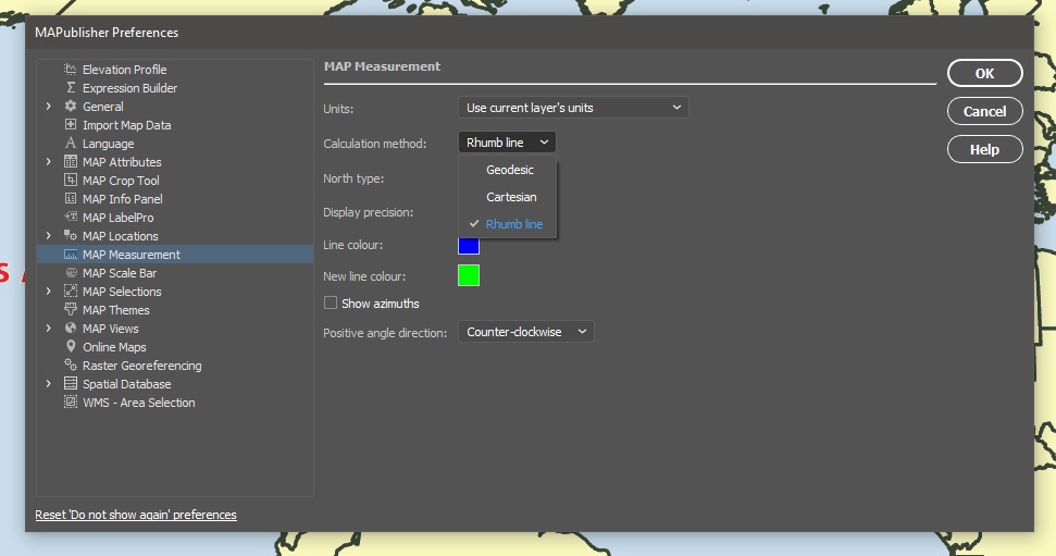
Enhancements and new features of MAPublisher 10.7

  • Compatible with Adobe Illustrator 2021 on Mac and Windows
  • Compatible with macOS 11 Big Sur
  • Access Floating licenses from the Cloud
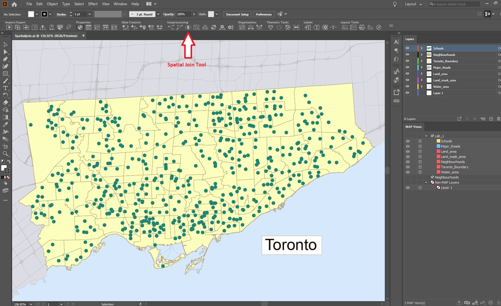
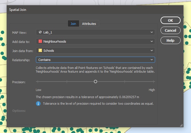
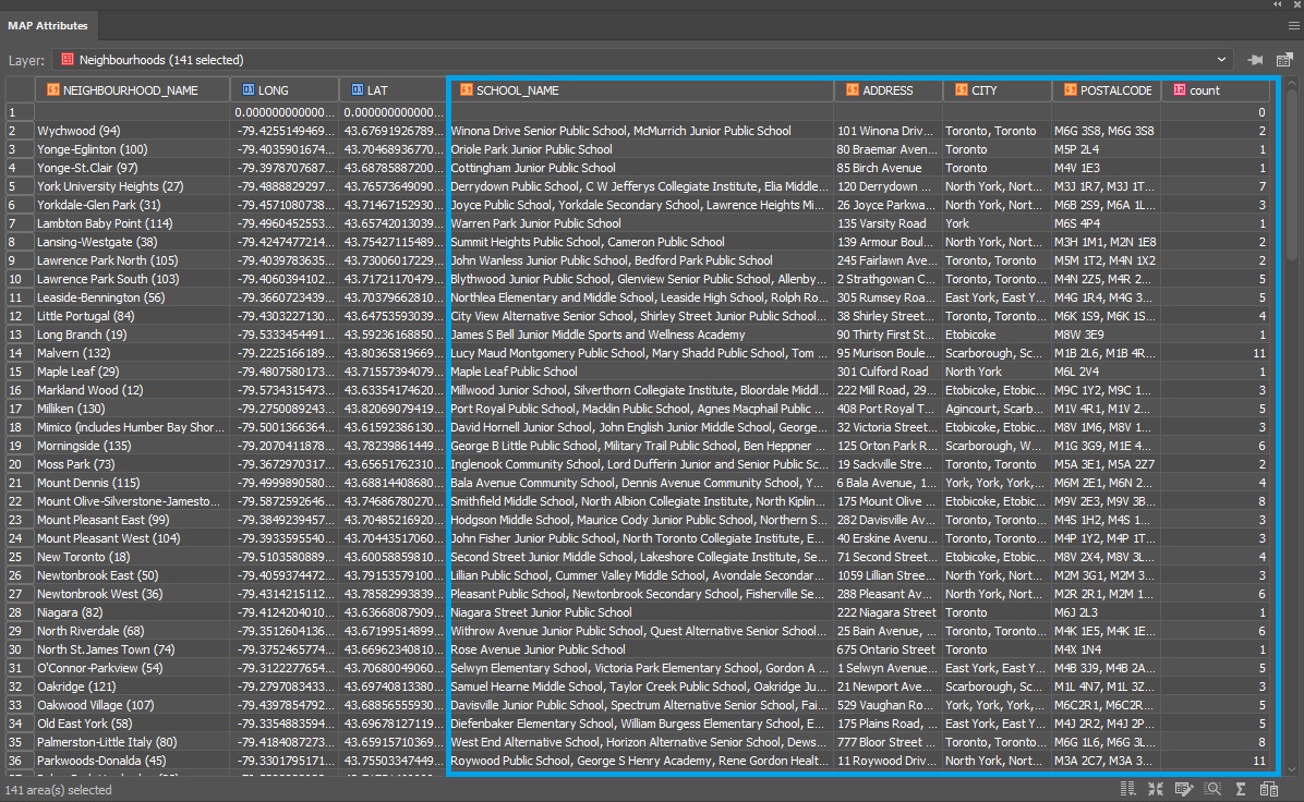
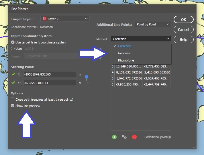
  • User interface and usability enhancements


MAPublisher 10.7 is immediately available free of charge to all current MAPublisher users with active maintenance and as an upgrade for non-maintenance users starting at US$599. New licenses are available from US$1399. MAPublisher FME Auto and MAPublisher LabelPro are also available as add-ons starting at US$399. Academic, floating, and volume licences are also available. Prices include one year of full maintenance. Visit www.avenza.com/mapublisher for more details.

More about Avenza Systems Inc.

Avenza Systems Inc. is an award-winning, privately held corporation that provides cartographers and GIS professionals with powerful software tools to make better maps. In addition to desktop mapping software, Avenza offers the mobile Avenza Maps app to sell, purchase, distribute, and use maps on iOS and Android devices. For more information, visit www.avenza.com.

For further information contact:  416-487-5116 – info@avenza.comwww.avenza.com

Avenza Releases Geographic Imager 6.2 for Adobe Photoshop

Toronto, ON, October 21, 2020 – Avenza Systems Inc., producers of the Avenza Maps® app for mobile devices and geospatial plugins for Adobe Creative Cloud®, including MAPublisher® for Adobe Illustrator®, is pleased to announce the release of Geographic Imager® 6.2. This latest version is powered by Adobe’s new Unified Extensibility Platform (UXP), which provides tremendous performance and user interface improvements to the Geographic Imager plugin for Adobe Photoshop.

“Geographic Imager has become a product many organizations trust and depend on to quickly edit and process spatial imagery,” said Ted Florence, President of Avenza Systems. “With increased performance and even more opportunities to develop new tools and experiences with UXP, the possibilities are endless.”

Powering the Geospatial Imagery Editing Process

Geographic Imager for Adobe Photoshop® delivers an all-encompassing solution to import, edit, and export geospatial images such as aerial and satellite imagery. Work with digital elevation models, GeoTIFFs, and other popular GIS image formats while using Adobe Photoshop® features such as transparencies, filters, cropping and image adjustments; all while maintaining georeferencing and support for hundreds of coordinate systems and projections.

New features of the Geographic Imager 6.2 plugin for Adobe Photoshop® include:

  • Compatibility: Fully compatible with Adobe Photoshop® 2021 on both Windows and Mac, powered by Adobe’s new Unified Extensibility Platform (UXP)
  • Exporting: Vector map data is now able to export to many industry geospatial formats
  • Advanced Importing: Ability to remove backgrounds from images during import


Geographic Imager is immediately available and free of charge to all current Geographic Imager Maintenance Program members and starts at US$319 for non-maintenance upgrades. New fixed licenses start at US$699. Geographic Imager Basic Edition licenses start at US$99. Academic, floating and volume license pricing is also available.
For more information, visit www.avenza.com/geographic-imager.

More about Avenza Systems Inc.

Avenza Systems Inc. is an award-winning, privately held corporation that provides cartographers and GIS professionals with powerful software tools to make better maps. In addition to desktop mapping software, Avenza offers the mobile Avenza Maps app to sell, purchase, distribute, and use maps on iOS and Android devices. For more information, visit www.avenza.com.

For further information contact: 416-487-5116 – info@avenza.com – www.avenza.com

How we’re dealing with the COVID-19 situation

Dear Valued Avenza Customers,

I know that everyone is concerned about COVID-19 which has us all feeling uneasy and unsure about short and long-term plans and the overall impact of this global pandemic. This is why I am personally reaching out to you today to let you know that Avenza feels it too and we are here to help wherever we can.

As the public health situation around COVID-19 continues to evolve, Avenza is doing its best to support our users and keep the lines of communication open while balancing that with ensuring the health and safety of our employees and performing our social responsibility to curtail the spread of the virus. 

In heeding all government and health professional directives and to support social distancing within our own offices, we have directed and empowered all our staff to work from home during this crisis period. This flexibility and understanding will help protect their well-being and allow them to continue to stay productive during these uncertain times. We are virtually maintaining our regular office hours and are available through many of our social media and support channels, email, and of course by telephone. Our priority is to continue to provide the dependable and personalized service you’ve become accustomed to receiving, while as a number one priority protecting the health and well-being of our staff, their families, and the public at large.

You will have probably now seen many of these types of notices but I want to assure you that we are here, active and available to support you as may be necessary so that you may also continue to remain working and productive.


Sincerely, 

Ted Florence

President
Avenza Systems Inc.


What’s New in MAPublisher 10.6

Continued Compatibility with Adobe 2020

Both Windows (64-bit) and Mac users can explore the exciting new and improved features MAPublisher 10.6 offers with the latest version of Adobe Illustrator. Talk about a power duo — upgrade today (it’s free for maintenance users)!

Spatial Join

In our line of work, spatial relationships are really important and can be complicated, but working with them shouldn’t be. MAPublisher 10.6 delivers the brand-new Spatial Join feature and we’re ecstatic to be sharing it with you. With Spatial Join, you can:

  • copy attributes from one layer to another based on their spatial relationship
  • use relationships including Near, Closest, Identical To, Contains, Within, Has Centre In, and Intersects
  • adjust the Precision and Tolerance


Spatial Join Tool

Spatial Join Tool MAPublisher 10.6

Spatial Join tool

Spatial Join for MAPublisher 10.6

Features joined based on spatial relationship

Improved Line Plotter

The Earth isn’t flat, and your plotted lines shouldn’t be either! The improved Line Plotter tool will accurately plot lines with the Geodesic and Rhumb line methods, taking your projection into consideration (or calculation if we’re getting technical) and is available for both Point by Point and Course & Distance plotting styles.

The Rhumb line method will create either straight or curved lines, depending on the projection used. Still want to plot straight lines? The Cartesian method is sticking around and will work just as you remember it. A preview option is now available, so you can take a look at the three different methods on your map before plotting the line (or simply turn it off if your line has too many points).

Line Plotter Settings MAPublisher 10.6

geodesic_lineplotter MAPublisher 10.6

Geodesic Method: Shortest distance between points

Rhumbline Line Plotter MAPublisher 10.6

Rhumb lines: Constant bearing, curved or straight depending on the map projection.

cartesian_lineplotter MAPublisher 10.6

Cartesian lines: straight lines from destination to destination.

Improved Map Measurement Tool

linemeasurement Settings MAPublisher 10.6


With the addition of the Geodesic and Rhumb methods for plotting lines, we’ve made sure you can accurately measure the distance between points with these methods as well, whether they’re curved or straight lines.

  • Measure distances between points using Geodesic, Cartesian and Rhumb line methods
  • Like the Line Plotter, Geodesic and Rhumb measurement lines can be curved or straight, depending on the map projection
  • A combination of keyboard presses (Shift + Click) will add the measurement line as an object on your layer

Rhumbline Measurement MAPublisher 10.6

Rhumb Measurement Line

Geodesic Measurement Line MAPublisher 10.6

Geodesic measurement line

cartesian_measurement MAPublisher 10.6

Cartesian Measurement Line

Installer Will Uninstall Previous Versions

We’ve made some improvements to the installer. You’ll notice that the MAPublisher 10.6 installer will prompt you to uninstall previous versions of MAPublisher. We’ve designed the installer to guide you through this process. You can also uninstall older versions through the Control Panel (Windows) or as usually on macOS.

Export Document to Image

Colours on a map can make important information pop or sometimes they just make the map look nice. Whichever way, we’ve made sure your colour profiles stick around when exporting your document to an image. ICC profiles (the data that characterizes a coloured input or output device) will be embedded when documents are exported as TIFF files. If an Adobe Illustrator document is in the CMYK colour space, its colour profile will be embedded in the TIFF if the exported TIFF’s colour mode is also set to CMYK.

Map Data Links

We’ve made it easier to keep your workspace clean. Previously, when a layer is deleted, data links were not removed. In MAPublisher 10.6, data links are now removed when a layer is deleted and is the new default behaviour.

Stay safe out there and happy Spring cleaning!

Avenza Maps 3.9 Release Integrates what3words

Avenza Maps version 3.9 is now available for users on iOS and Android devices! We have added features for both our recreational and Pro subscription users and made some improvements based on user feedback. This update of Avenza Maps includes some great features including the integration of what3words. Now anyone can identify their location by simply using three words. This is a very useful feature for recreational and outdoor enthusiasts as well as professionals who use Avenza Maps in remote locations. You can find the what3words for any 3m square in the world on any map. Here are more new features in this release:

GPX Import (Pro and Plus)

Hurray! Pro and Plus users can now import GPX files. Our users have been asking for it and now GPX files containing tracks, routes, and waypoints can be imported onto any map.

Avenza Maps GPX Route


Course-Up Map View Mode

When Course-up is enabled on the Location tab, the map view automatically rotates in accordance with your direction of travel.

Avenza Maps Course-up View

Registration Links (Pro)

Avenza Maps Pro admins can distribute Registration Links to field users who can interact with them to automatically register for Avenza Maps Pro with their organization.

New Coordinate Display Formats

Several new coordinate formats are now available in Avenza Maps, including what3words, British National Grid (a Pro feature with a limited preview for all users), and Universal Transverse Mercator.

what3words is live in Avenza Maps and has given every 3m square in the world a unique 3 word address, making it easier for people to communicate precise locations. With the new what3words feature you can set accurate waypoints, plot your favourite points along hiking trails or cycling routes and identify your own location – using just three words. supply.founders.outreach, for example, is the 3-word address for the front entrance to Avenza Systems’ head office in Midtown, Toronto. The what3words location is included in every placemark dropped on a map and can be copied and shared.

Avenza Maps what3words

Learn more about how what3words is integrated into Avenza Maps on avenzamaps.com.

There are some big changes and improvements in this version of the app and we’re very excited about it. Our goal is always to ensure that Avenza Maps users can navigate safely, track efficiently, and collect data even more precisely in the app.


News Archive