My Account     Contact Us     Cart

Articles

Avenza State Plane Coordinate System Map

MAPublisher and Geographic Imager provide an extensive library of predefined coordinate systems available for referencing or transforming mapping projects.
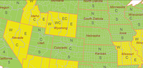
In the United States, the NGS (National Geodetic Survey), a department of NOAA (National Oceanic and Atmospheric Administration) has established a system that divides the United States into 124 zones, each with its own custom projected coordinate system. This system is known as the State Plane Coordinate System. It is important to note that there are two sets of State Plane coordinate systems defined in the United States, one based on the North American Datum of 1927 and the other based on the North American Datum of 1983. In addition to NAD 83, the NAD83 HARN and NSRS2007 adjustments are available for use. All three versions of NAD83 are available in metres, feet or international feet.

State Plane Coorindate Systems projections

There are four projections for SPCS. The geometric direction of each state determines the projection utilized. For states that are longer in the east-west direction, the Lambert Conformal Conic is used. States which are longer in the north-south direction use the Transverse Mercator projection. The panhandle of Alaska, which has the sole distinction of lying at an angle, garners the use of the Oblique Mercator projection, while Guam uses a Polyconic projection.

These coordinates systems are all defined in the MAPublisher and Geographic Imager library, however the initial question “which one do I need to use for my map” cannot be answered by the software itself.

There are a number of ways to determine in which zone your American area of interest lies. One online resource, searchable by latitude and longitude coordinates, can be found on this NGS website.

In an effort to better assist mapmakers in their selection of the appropriate system, the Avenza support team has prepared a searchable interactive map using MAPublisher 8.2 MAP Web Author tool. View the SPCS map here.

A MAPublisher geospatial PDF of the same map is also available for download here.

Transform into State Plane Coorindate Systems using MAPublisher

When it comes time to transform your data into the appropriate State Plane Coordinate System zone, use the MAP View Editor Perform Coordinates System Transformation option. When you specify the destination coordinate system for the transformation, navigate to Coordinate Systems > Projected > North America > United States > US State Plane NAD 83 – on the right hand list, you’ll find all the state plane zones sorted by state name and zone name: select the right one!
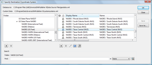
Note: similarly you can select the NAD27 state plane systems from Coordinate Systems > Projected > North America > United States > US State Plane NAD 27 if appropriate.

Improved Reprojection Engine in MAPublisher 8.3

One of the exciting new changes in MAPublisher 8.3 is that we’ve substantially rewritten our reprojection engine. What I’d like to do here is explain what the changes are, and what they mean for you, the user.

The old reprojection engine was point-by-point. Essentially, we walked each path and simply reprojected each point one by one. This simple approach works very well but it has one important deficiency: it lacks context. The internal reprojection system never sees anything more than a single point, and therefore is limited to just reprojecting.

So what is the new system doing? Our new reprojection engine is performed feature-by-feature. This is important because it means the internal system no longer just sees a single point, but rather a collection of points and how they are arranged. This means it can notice things like an area that wraps around to the other side of the world! In the old system, it would just blindly punch out points, and if a path suddenly jumped to the other side of the page, well, that’s where the path went. But now the reprojection engine can notice things like that, and clip the art appropriately. If necessary, it will even break a single path into a compound path! But it’s probably easier to understand if we demonstrate it visually.

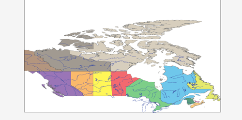
Here is a map of Canada with two layers: rivers & provinces. Both sets of art are coloured nicely and the provinces layer even has an opacity reduction to make the rivers stand out a little.

Before transform

I’ve created a new coordinate system I’ve called ‘Miller Cylindrical Shifted’. I just made a copy of the ‘Miller Cylindrical’ coordinate system and then altered my copy’s central meridian to be 90 instead of zero. I did this so that if I reproject Canada into ‘Miller Cylindrical Shifted’, half of Canada should be on the left-hand side, and half should be on the right-hand side. Let’s see how MAPublisher 8.2 handles it:

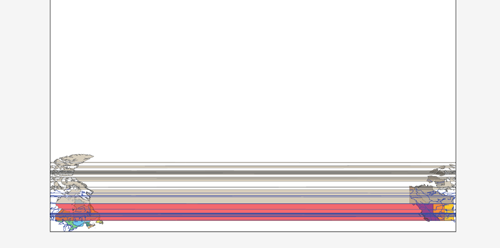
After transform in 8.2

Yikes! The old reprojection engine had no idea that some of those lines were going off the end of the projection’s envelope!

Now let’s try it in MAPublisher 8.3 with the new reprojection engine:

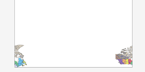
After transform in 8.3

Wow! What a difference feature-by-feature makes! The new engine recognizes that those paths needed to be clipped and properly split polygons and lines as needed. It’s also important to note that the areas & lines are still intact. e.g. Northwest Territories was split, but it’s still a single compound path with all of its islands — some of those islands have simply been split into pieces. The split even preserves all the original path’s properties, including attributes and styles!

News Archive

Blog Archive

December 2024 (1)
November 2024 (1)
October 2024 (1)
November 2024 (1)
September 2024 (1)
August 2024 (2)
July 2024 (1)
September 2024 (1)
June 2024 (1)
July 2024 (1)
May 2024 (1)
April 2024 (2)
May 2024 (1)
March 2024 (2)
February 2024 (1)
January 2024 (1)
December 2023 (1)
November 2023 (2)
October 2023 (2)
September 2023 (1)
August 2023 (1)
July 2023 (3)
June 2023 (1)
February 2023 (1)
January 2023 (2)
December 2022 (1)
November 2022 (2)
October 2022 (2)
September 2022 (1)
May 2023 (1)
August 2022 (2)
July 2022 (1)
June 2022 (2)
May 2022 (1)
February 2022 (1)
January 2022 (2)
August 2022 (1)
December 2021 (3)
November 2021 (5)
October 2021 (1)
September 2021 (3)
August 2021 (2)
July 2021 (1)
June 2021 (2)
May 2021 (2)
April 2021 (2)
March 2021 (3)
April 2021 (1)
February 2021 (1)
January 2021 (1)
November 2020 (1)
October 2020 (1)
June 2020 (2)
May 2020 (1)
April 2020 (3)
March 2020 (2)
December 2019 (1)
November 2019 (2)
September 2019 (1)
August 2019 (1)
July 2019 (1)
June 2019 (3)
May 2019 (4)
April 2019 (2)
March 2019 (1)
February 2019 (2)
January 2019 (3)
December 2018 (2)
November 2018 (1)
October 2018 (1)
September 2018 (2)
August 2018 (4)
July 2018 (2)
June 2018 (1)
July 2018 (1)
June 2018 (4)
May 2018 (1)
April 2018 (2)
March 2018 (4)
February 2021 (1)
February 2018 (1)
January 2018 (1)
November 2017 (1)
October 2017 (2)
August 2017 (2)
July 2017 (1)
March 2017 (1)
February 2017 (2)
January 2017 (2)
November 2016 (1)
January 2017 (1)
November 2016 (1)
October 2016 (2)
May 2016 (1)
March 2018 (1)
April 2016 (2)
December 2015 (2)
June 2015 (1)
May 2015 (1)
April 2015 (2)
December 2014 (4)
October 2014 (2)
May 2014 (4)
February 2014 (1)
October 2013 (3)
April 2013 (1)
January 2013 (2)
August 2012 (1)
October 2012 (1)
July 2012 (3)
May 2012 (2)
January 2012 (2)
August 2011 (1)
July 2011 (2)
June 2011 (2)
May 2011 (2)
March 2011 (1)
February 2011 (1)
January 2011 (5)
December 2010 (1)
November 2010 (1)
December 2010 (1)
November 2010 (1)
October 2010 (1)
August 2010 (4)
July 2010 (2)
June 2010 (3)
May 2010 (2)
April 2010 (2)
March 2010 (2)