My Account     Contact Us     Cart

Articles

Import Geodatabase Feature Classes into Adobe Illustrator

In this post, we’ll cover how simple it is to import a geodatabase feature class into Adobe Illustrator using MAPublisher import tools enabled with the Spatial Database add-on.
Imported features

Spatial databases are optimized data repositories for spatial data storage and management. Many GIS environments use spatial databases to easily access and manage GIS data in a central location.

MAPublisher 8.2 introduces support for import of the popular ESRI single-user and multi-user Geodatabases: Personal, File and ArcSDE Geodatabases; and direct access to ArcSDE server. The MAPublisher Spatial Database importer is built on ESRI software libraries and requires a valid ESRI software and license installed on the computer (ArcGIS 9.2 and higher).

To import one, you can use either Simple Import or Advanced Import. In this scenario, we’ll use Advanced Import. When we add data, a list of Geodatabase types are located at the bottom of the Format list. We’ll be importing some feature classes from a simple geodatabase consisting of waterlines, hydrants and valves.
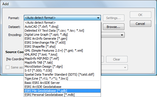
Add dialog box

After browsing for the geodatabase (a File geodatabase in this case), the Select Feature Classes dialog box appears. We’ll go ahead and select a few feature classes from the Landbase and Water feature sets listed.
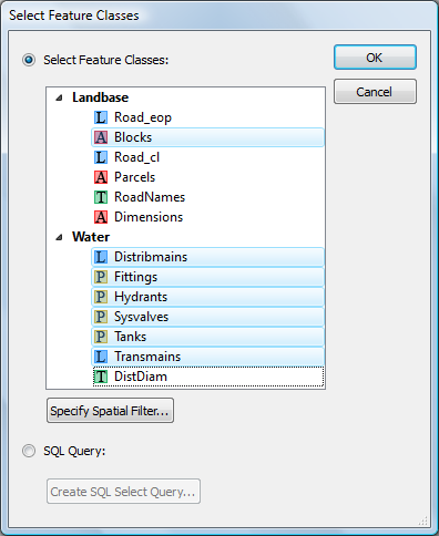
Select Feature Classes

The Advanced Import dialog box shows the number of features being imported and the coordinate system as well as page and map anchors.
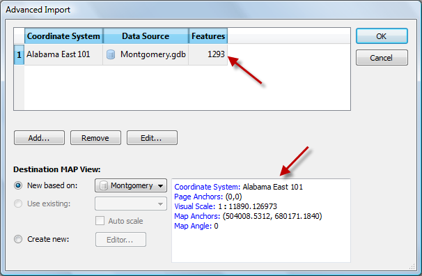
Confirm geodatabase import

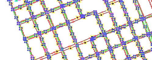
The features are imported and are ready to be used in a map.

Imported features

Easy Transformations in MAPublisher

MAP Views are designed to provide an easy method of accessing settings for specifying and transforming coordinate systems, for editing scale and data placement on the page and for exporting to GIS formats. The MAP Views panel allows for merging Adobe Illustrator layers, georeferencing existing Adobe Illustrator artwork, changing multiple layer names, and reprojecting data on the fly.

That said, it’s possible to create multiple MAP Views that each contain a different projected coordinate system in a single map document. The MAP Views panel can be used to move Adobe Illustrator layers from one MAP View to another, enabling to reproject vector art quickly. Layers can be moved via drag-and-drop or with the new Switch MAP View button. This is useful when testing how a variety of projections may fit into your layout. It’s also useful for creating inset or key maps.

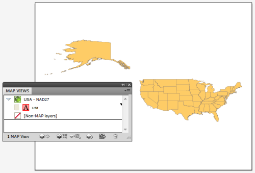
Here we have one MAP View called USA – NAD27. As the name of it implies, it is in a NAD27 projection. Let’s go ahead and make another MAP View so that we can perform an easy transformation.

USA in NAD27

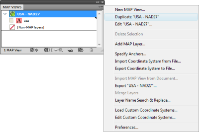
Click the USA – NAD27 MAP View to highlight it, then click the panel option menu (upper right corner) and click Duplicate “USA – NAD27”.

Duplicate MAP View

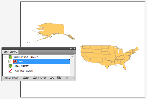
This creates a Copy of USA – NAD27 MAP View. Double-click the Copy of USA – NAD27 MAP View to edit it.

Copy MAP View

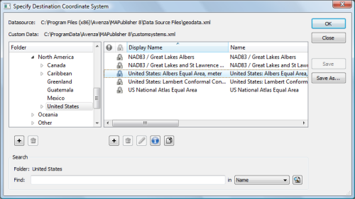
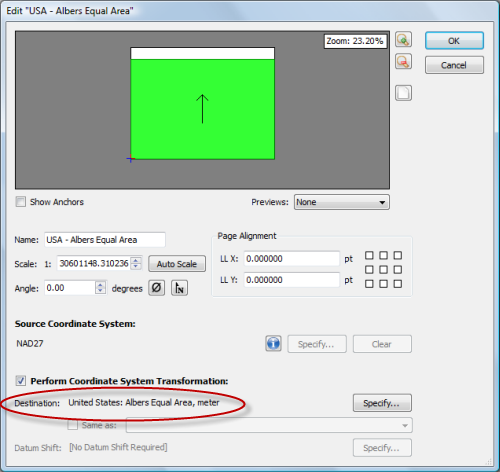
In the MAP View editor, change the title to USA – Albers Equal Area in the Name box. Below you can see that it is currently in NAD27. Check the Perform Coordinate System Transformation check box and click Specify. In the Specify Coordinate System dialog box, in the Folder list, navigate to Projected > North America > United States and click United States: Albers Equal Area, meter in the right-hand pane. Click OK.

Choose Albers Equal Area

Back in the MAP View editor box, you’ll see that the Destination is updated to show the United States: Albers Equal Area projection. Click OK.

MAP View editor

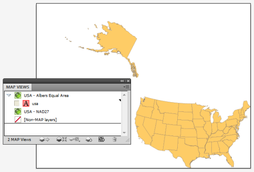
The map is reprojected from NAD27 to Albers Equal Area.

Albers Equal Area projection

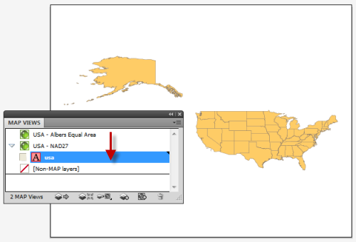
To reproject-on-the-fly by drag-and-drop, click the usa area layer and just drag it to the USA – NAD27 MAP View. Now you can switch back and forth between projections. You may want to duplicate the usa area layer in the Layers panel so that you can have two different projections at the same time. Remember to use the MAP View editor if you want to move a MAP view to retain spatial referencing.

Back to NAD27

To learn more about MAP Views, view Chapter 4 of the MAPublisher user guide.

News Archive

Blog Archive

December 2024 (2)
November 2024 (2)
October 2024 (1)
September 2024 (1)
August 2024 (2)
July 2024 (1)
September 2024 (1)
June 2024 (1)
July 2024 (1)
May 2024 (1)
April 2024 (2)
May 2024 (1)
March 2024 (2)
February 2024 (1)
January 2024 (1)
December 2023 (1)
November 2023 (2)
October 2023 (2)
September 2023 (1)
August 2023 (1)
July 2023 (3)
June 2023 (1)
February 2023 (1)
January 2023 (2)
December 2022 (1)
November 2022 (2)
October 2022 (2)
September 2022 (1)
May 2023 (1)
August 2022 (2)
July 2022 (1)
June 2022 (2)
May 2022 (1)
February 2022 (1)
January 2022 (2)
August 2022 (1)
December 2021 (3)
November 2021 (5)
October 2021 (1)
September 2021 (3)
August 2021 (2)
July 2021 (1)
June 2021 (2)
May 2021 (2)
April 2021 (2)
March 2021 (3)
April 2021 (1)
February 2021 (1)
January 2021 (1)
November 2020 (1)
October 2020 (1)
June 2020 (2)
May 2020 (1)
April 2020 (3)
March 2020 (2)
December 2019 (1)
November 2019 (2)
September 2019 (1)
August 2019 (1)
July 2019 (1)
June 2019 (3)
May 2019 (4)
April 2019 (2)
March 2019 (1)
February 2019 (2)
January 2019 (3)
December 2018 (2)
November 2018 (1)
October 2018 (1)
September 2018 (2)
August 2018 (4)
July 2018 (2)
June 2018 (1)
July 2018 (1)
June 2018 (4)
May 2018 (1)
April 2018 (2)
March 2018 (4)
February 2021 (1)
February 2018 (1)
January 2018 (1)
November 2017 (1)
October 2017 (2)
August 2017 (2)
July 2017 (1)
March 2017 (1)
February 2017 (2)
January 2017 (2)
November 2016 (1)
January 2017 (1)
November 2016 (1)
October 2016 (2)
May 2016 (1)
March 2018 (1)
April 2016 (2)
December 2015 (2)
June 2015 (1)
May 2015 (1)
April 2015 (2)
December 2014 (4)
October 2014 (2)
May 2014 (4)
February 2014 (1)
October 2013 (3)
April 2013 (1)
January 2013 (2)
August 2012 (1)
October 2012 (1)
July 2012 (3)
May 2012 (2)
January 2012 (2)
August 2011 (1)
July 2011 (2)
June 2011 (2)
May 2011 (2)
March 2011 (1)
February 2011 (1)
January 2011 (5)
December 2010 (1)
November 2010 (1)
December 2010 (1)
November 2010 (1)
October 2010 (1)
August 2010 (4)
July 2010 (2)
June 2010 (3)
May 2010 (2)
April 2010 (2)
March 2010 (2)