My Account     Contact Us     Cart

MAPublisher Training – Dallas, TX

Dallas, TX – May 10-11, 2018

New Horizons Computer Learning Centers
150 W John Carpenter Freeway, Suite 100, Irving, TX 75039, USA

Reserve Now


Whether you’re new to MAPublisher®, an experienced user, or simply thinking about a purchase, Avenza software training is a worthwhile experience. Get hands-on training from Avenza product specialists at one of our training courses around North America.

Who should attend?

  • GIS professionals who want to produce better quality maps
  • Map makers and cartographers incorporating GIS data to improve accuracy in their maps
  • New MAPublisher users who just purchased a license
  • Users who want to experience the latest features of MAPublisher


Cost

Cost of the two-day training course is $1,000 USD per person. Discounts are available to groups of three or more from the same organization and for returning students desiring a refresher or update. Major credit cards are accepted.

Training details

  • Hands-on training takes place at a training center classroom where Windows computers and all required software and training data are provided.
  • Attendees will learn the fundamentals of MAPublisher and learn how to use all major features. Attendees will also receive basic instruction on the use of Adobe Illustrator as it relates to MAPublisher and cartographic production. A basic knowledge of Adobe Illustrator is recommended, but not required.
  • Attendees are encouraged to bring his or her own datasets. There will be some time during the end of the course to discuss these with an instructor.
  • Attendees that are Mac users may opt to bring his or her own Mac and software. Make sure to inform Avenza a week before training to setup the system properly for training.
  • Classes may be cancelled up to fifteen business days prior to the confirmed training date (depending on the number of reservations received).

MAPublisher Training – Seattle, WA

Seattle, WA – September 27-28, 2018

Computer Classrooms in Seattle
10604 NE 38th Place, Suite 118, Kirkland, WA 98033, USA

Reserve Now


Whether you’re new to MAPublisher®, an experienced user, or simply thinking about a purchase, Avenza software training is a worthwhile experience. Get hands-on training from Avenza product specialists at one of our training courses around North America.

Who should attend?

  • GIS professionals who want to produce better quality maps
  • Map makers and cartographers incorporating GIS data to improve accuracy in their maps
  • New MAPublisher users who just purchased a license
  • Users who want to experience the latest features of MAPublisher


Cost

Cost of the two-day training course is $1,000 USD per person. Discounts are available to groups of three or more from the same organization and for returning students desiring a refresher or update. Major credit cards are accepted.

Training details

  • Hands-on training takes place at a training center classroom where Windows computers and all required software and training data are provided.
  • Attendees will learn the fundamentals of MAPublisher and learn how to use all major features. Attendees will also receive basic instruction on the use of Adobe Illustrator as it relates to MAPublisher and cartographic production. A basic knowledge of Adobe Illustrator is recommended, but not required.
  • Attendees are encouraged to bring his or her own datasets. There will be some time during the end of the course to discuss these with an instructor.
  • Attendees that are Mac users may opt to bring his or her own Mac and software. Make sure to inform Avenza a week before training to setup the system properly for training.
  • Classes may be cancelled up to fifteen business days prior to the confirmed training date (depending on the number of reservations received).

Avenza Releases MAPublisher 10 For Adobe Illustrator

Adobe CC 2018 compatibility and data link management

Toronto, ON, November 14, 2017 – Avenza Systems Inc., producers of the Avenza Maps® app for mobile devices and geospatial plug-ins for Adobe Creative Cloud, including Geographic Imager® for Adobe Photoshop®, is pleased to announce the release of MAPublisher® 10 for Adobe Illustrator. This latest update includes many new features and enhancements including full compatibility with Adobe Illustrator Creative Cloud 2018.

This MAPublisher release introduces the ability to manage data links where MAP layers in a document can be updated when its source data has been modified. “We’ve reached out for valuable user feedback since our last release and have heard many requests for improved GIS data management and streamlined import,” said Ted Florence, President of Avenza. “By developing and implementing features from this feedback, we’re committed to maintaining MAPublisher as the industry-standard cartography tool to help map makers create amazing products for print, mobile, and web.”

Enhancements and new features of MAPublisher 10

  • Fully compatible with the latest Adobe Illustrator CC 2018 on both Windows (32-bit and 64-bit) and Mac
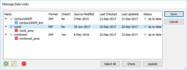
  • New ability to create and manage data links for MAPublisher documents. MAP layers in a document can be updated when its source data has been modified.
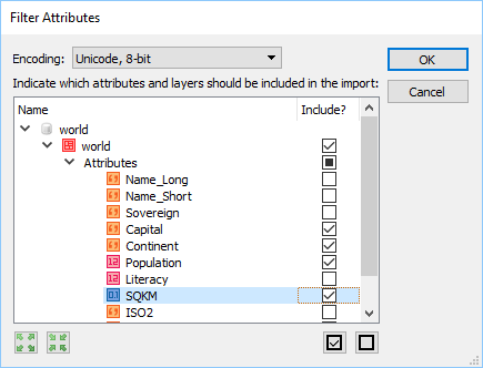
  • New attribute filter capability to select which layers and attributes to include or exclude prior to import
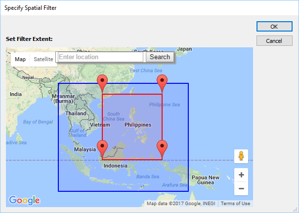
  • New geometry filter capability to select which features to include or exclude prior to import
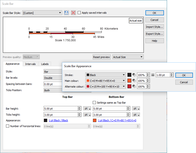
  • New scale bar styles and customization options including ability to save, import, and export scale bar styles
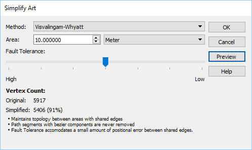
  • New Visvalingam-Whyatt simplification method and fault tolerance settings to simplify art
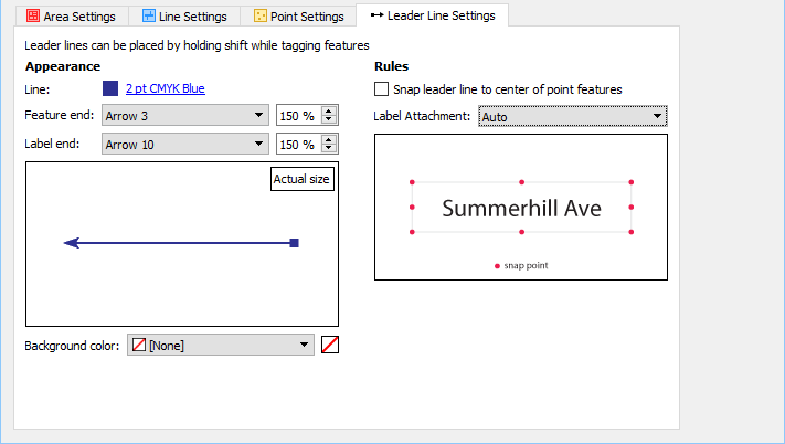
  • New MAP Tagger Tool ability to create custom leader lines with various arrow styles and an option to snap leader line to different positions around a label
  • A new Point Utilities action that can rotate points to the angle of latitude
  • A modified Text Utilities action that can draw a point for text based upon text alignment for indexing purposes
  • New settings for North Arrow location including True North and a custom coordinate and options to use Great Circle or compass method.
  • New MAP Web Author HTML5 export customization options including adjustable scale bar.
  • A number of user interface and usability enhancements.


More about MAPublisher for Adobe Illustrator

MAPublisher for Adobe Illustrator is powerful map production software for creating high-quality maps from GIS data. MAPublisher cartographic tools leverage the superior graphic design environment of Adobe Illustrator to manipulate features and produce print-ready, mobile, and online maps with accuracy and efficiency.

MAPublisher 10 is available free of charge to all MAPublisher users with an active maintenance subscription and as an upgrade for non-maintenance users starting at US$599. New commercial licenses are available from US$1399. MAPublisher FME Auto and MAPublisher LabelPro are also available as add-ons starting at US$399 per license. Floating and volume pricing are also available. Prices include one year of full maintenance. Visit www.avenza.com/mapublisher for more details.

More about Avenza Systems Inc.

Avenza Systems Inc. is an award-winning, privately held corporation that provides cartographers and GIS professionals with powerful software tools to make better maps. In addition to desktop software offerings for Mac and Windows users, Avenza offers product training, as well as the Avenza Maps app for purchasing and using maps on iOS and Android mobile devices. Visit www.avenza.com for more details.

For further information contact:
Avenza Systems
416-487-5116
info@avenza.com
www.avenza.com

###


MAPublisher 10 Released

We’re excited to announce that we’ve released MAPublisher 10 for Adobe Illustrator. The MAPublisher product team has been working closely with our customers to build more useful features, tools, and to improve the look and feel.

MAPublisher 10
This update contains new features and performance improvements as well as fixes for reported bugs. Some highlights are mentioned below, for the full release notes see below.

Adobe Illustrator Creative Cloud 2018 support. We are fully committed to providing the best map design tools seamlessly built into Adobe Illustrator. We have improved our user interface (panels, tools, buttons) to support high-resolution monitors. This release is fully compatible with the latest Adobe Illustrator CC 2018 on both Windows (32-bit and 64-bit) and Mac.

Manage Data Links. This feature has long been requested by our customers. You now have the ability to create and manage data links for MAPublisher documents. MAP layers in a document can be updated when its source data has been modified. Data links are checked automatically every time a document is opened and will display the status of affected layers in the MAP Views panel. This allows you to keep track of data that may have been moved or modified. When a data source is missing, a notification will alert you in both the Edit Data Link dialog box and MAP View panel. Note that only the link is dynamic and not the actual map features, meaning that manipulating your features in the document does not directly affect the source data. You will need to export your data if you want to overwrite your source data.
Filter attributes and filter geometry on import. A common workflow our customers encounter is trying to reduce the amount of data being imported. Often times, a dataset covers a much larger area or has too many attributes included. There is now a way to streamline import so that it’s not only quicker to import, but also results in improved Adobe Illustrator performance due to the reduction in the number of map features on the artboard. The new attribute filter helps you  select which layer attributes (or layers) to include or not include prior to import. The new geometry filter provides several options (including an interactive map) to help you select which area to include or not include prior to import.
Redesigned Scale Bar tool. We’ve worked a lot with our customers to redesign the scale bar tool. In addition to new customization options, new scale bar styles were generated with the help of the US National Park Service, Harpers Ferry Center. You also now have the ability to save, import, and export scale bar styles, making it easier to share defined styles with others.
Improved MAP Tagger Tool. You now have the ability to create custom leader lines with various arrow styles and option to snap leader line to different positions around a label. This provides a new level of customization and efficiency without having to style leader lines afterwards.
New Simplify Art simplification method. A new Visvalingam-Whyatt simplification method and fault tolerance setting to accommodate positional error between shared edges in the topology. The Visvalingam-Whyatt method is an area based algorithm which eliminates points based on their effective area. By iterating through points of lines and areas, it calculates and removes the point with the least effective area.
 

MAPublisher 10 Release Notes

  • Fully compatible with the latest Adobe Illustrator CC 2018 on both Windows (32-bit and 64-bit) and Mac
  • New ability to create and manage data links for MAPublisher documents. MAP layers in a document can be updated when its source data has been modified.
  • New attribute filter capability to select which layers and attributes to include or exclude prior to import
  • New geometry filter capability to select which features to include or exclude prior to import
  • New scale bar styles and customization options including ability to save, import, and export scale bar styles
  • New Visvalingam-Whyatt simplification method and fault tolerance settings to simplify art
  • New MAP Tagger Tool ability to create custom leader lines with various arrow styles and an option to snap leader line to different positions around a label
  • A new Point Utilities action that can rotate points to the angle of latitude
  • A modified Text Utilities action that can draw a point for text based upon text alignment for indexing purposes
  • New settings for North Arrow location including True North and a custom coordinate and options to use Great Circle or compass method
  • New MAP Web Author HTML5 export customization options including adjustable scale bar
  • A number of user interface and usability enhancements.


News Archive