My Account     Contact Us     Cart

Easy Map Creation with WFS and WMS

Online services can be used to create high-quality maps without the need to download and maintain large spatial datasets or spend time designing base maps. In this post, we’ll use two online sources to import data and create a map showing the potential energy generated from existing and proposed wind power projects in the state of Massachusetts.
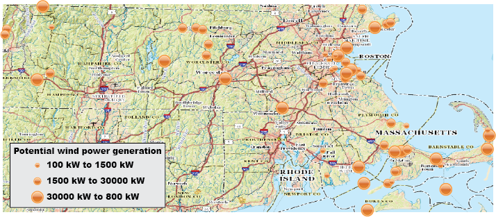
Wind map

There are two types of online mapping services MAPublisher can use to import layers: Web Map Services (WMS) and Web Feature Services (WFS). WMS is an interface for accessing geo-registered images from an online source. This means that users aren’t able to modify individual elements of a WMS layer and are only able to select an area of the map to import. WMS also allows for transparency so map layers can be overlaid on top of one another.

WFS, on the other hand, is an interface for accessing vector map features in GML format. Features are imported as a MAP Layer which can be further modified using MAPublisher and Illustrator tools. To create this map, we’ll import data from two sources: a topo map from the US Geological Survey (USGS) and the Massachusetts Office of Geographic Information (MassGIS).

To start, open Adobe Illustrator and create a new document in portrait mode. Import a MAP Layer and select Web Feature Service from the Format drop-down. Click the “Click to select services and layer(s)”. link. The MassGIS layers are included with MAPublisher by default. If you do not see this service, click Load Services from Avenza. Select Commonwealth of Massachusetts, USA – MassGIS in the USA folder.
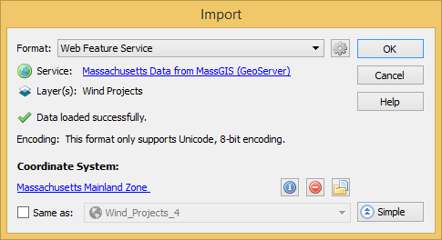
Selecting WFS for import

On the Select Features dialog box, select Wind Power. Note the default SRS – EPSG 26986. On the Import dialog box, click the link to select a coordinate system. Choose Massachusetts Mainland Zone (EPSG 26986). Click OK.
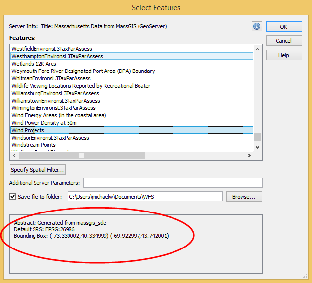
WFS information

The Wind Projects layer has been imported as a MAP Layer. It can be modified using MAPublisher or Illustrator tools to symbolize, label, select, and so forth. To create the style for this layer, add a new Stylesheet MAP Theme of Point feature type, then Batch generate rules for the KW column using three quantiles, and select Set scale so the symbols scale proportionally to the value. For more on how to replicate this style, see the MAPublisher Help article MAP Themes.
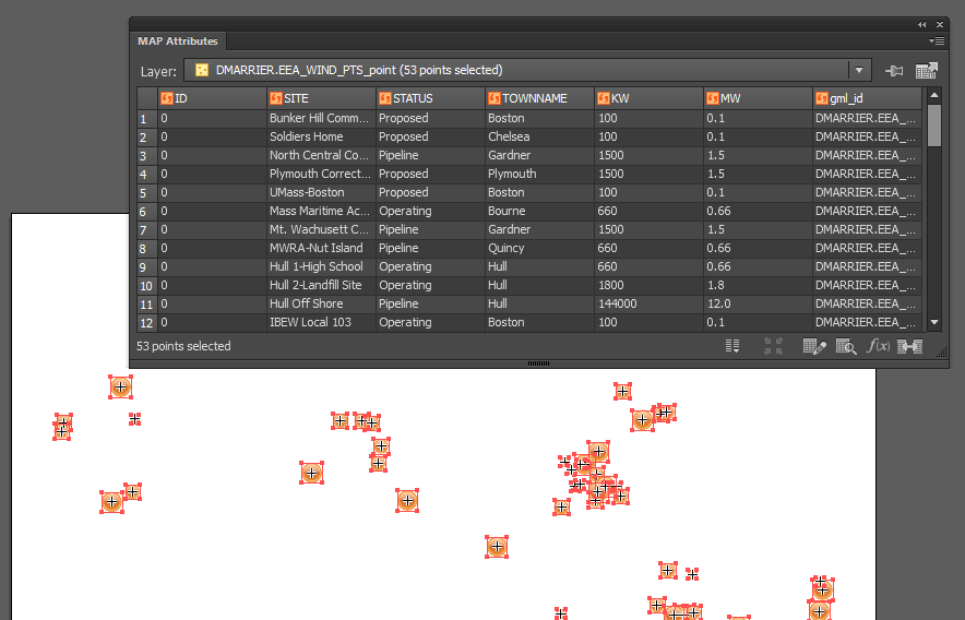
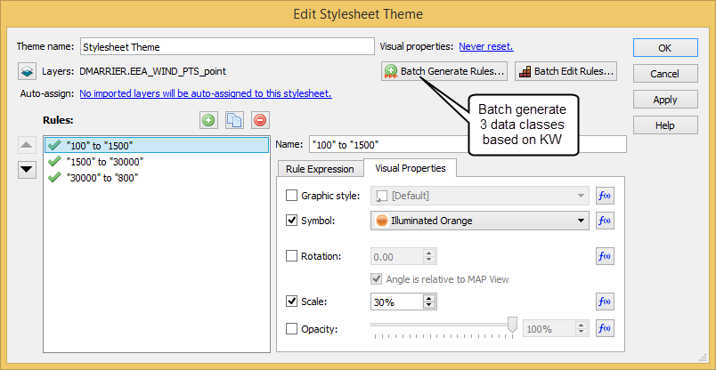
Wind point attributes (click to see larger image)
Batch generate rules

The next step is to import a WMS layer to use as a base layer. This map uses the USGS Topo Base Map which was created as part of the National Map program. A list of WMS and WFS services provided by USGS is available at http://viewer.nationalmap.gov/services/.

Go to the USGS web page and open the WMS link under Base Maps (Cached) > USGS Topo Base Map – Primary Tile Cache (Tiled). This is an XML document with the location and metadata of the WMS. Copy the link from the address bar and in Adobe Illustrator, click the MAPublisher Import button and choose Web Map Service from the Format drop-down menu. Click the “Click to select service and image” link. Click Add New Service and paste the URL into the GetCapabilities URL text box. Choose the service from the list and click OK.
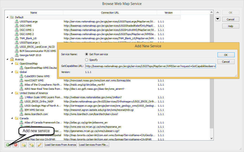
Add new service

On the Select Web Map Layer dialog box, choose USGS Topo Base Map from the Layers list. Set the Image Size to 1000 to increase the resolution. To change the extents of the output image click Select Area. This dialog box provides several options for setting the extents of the base map image. Click-and-drag to specify an area to select – the image will automatically crop. The buttons at the top of the panel allow you to enter the coordinate extents manually, match the extents of a MAP View or match the extents of a vector layer. Since we have already added the Wind Power layer to the map, we will set the extents to match this map view by clicking “Select area by MAP View” and choosing Wind_Projects from the drop-down menu. Leave the other options as default and import the base map image.
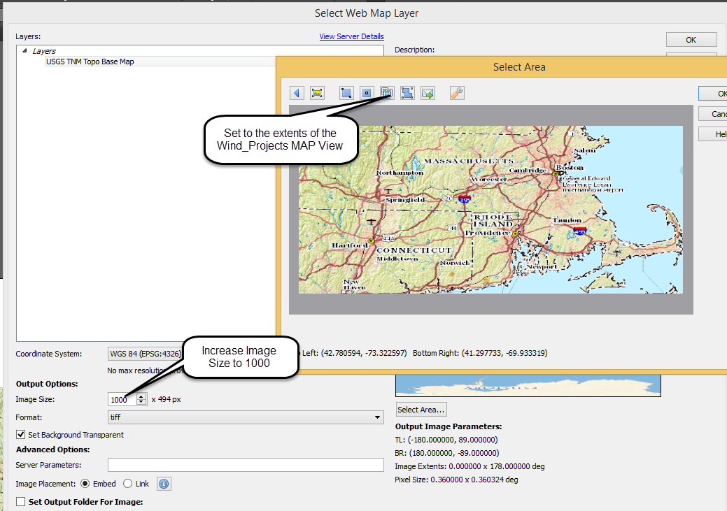
Select area

For the final step, open the MAP View panel and drag the layer DMARRIER.EEA_WIND_Point to the MAP View USGS_TNM_Toppo_Base_Map. This will transform the points to the same coordinate system as the base map.

There are thousands of freely available WMS and WFS sources available online. For a good starting place see this blog post from the Open Geospatial Consortium for advice on finding services. You could also use a basic web search – for example – “WMS Toronto” or similar. For more help on web services in MAPublisher see the help article Web Map/Feature Service.

Avenza Releases MAPublisher 9.7 for Adobe Illustrator

– Popular GeoPackage now a supported format –

Toronto, ON, May 11, 2016 – Avenza Systems Inc., producers of the PDF Maps app for mobile devices and geospatial plug-ins for Adobe Creative Cloud, including Geographic Imager® for Adobe Photoshop®, is pleased to announce the release of MAPublisher 9.7 for Adobe Illustrator. This latest update includes many new features including GeoPackage support. This release also introduces improvements to how Web Map Services are imported, making it easier manage services and to interactively select areas.

“We’re delighted to release MAPublisher 9.7 with support for the GeoPackage format,” said Ted Florence, President of Avenza. “GeoPackages are gaining popularity and is an important format to support in MAPublisher and other Avenza solutions moving forward,” he added. “We’re committed to providing our users the ability to use open and interoperable data sources to create high-quality maps and publishing to print, web and mobile.”

Enhancements and new features of MAPublisher 9.7

  • Fully compatible with Adobe Illustrator Creative Cloud 2015 on both Windows (32-bit and 64-bit) and Mac
  • Web Map Services (WMS) can now be managed and organized into folders. Selecting an area of a web map layer is now easier with improved selection tools.
  • The GeoPackage format, a platform-independent database that can contain raster data, is now supported in Export to Web Tiles and Export Document to GeoPackage
  • Map scales are now shown when selecting maximum zoom. Exporting to Web Tiles now includes GeoPackage as a map provider. A post export option allows you to open the destination folder containing the web tiles.
  • New MAPublisher help system is now online. Browse help topics for tools, features, and tutorials. Most MAPublisher dialog boxes now link directly to help topics.
  • MAPublisher FME Auto is now compatible with FME Desktop 2016.1
  • Various user interface and performance enhancements to improve usability


More about MAPublisher for Adobe Illustrator

MAPublisher for Adobe Illustrator is powerful map production software for creating high-quality maps from GIS data. MAPublisher cartographic tools leverage the superior graphic design capabilities of Adobe Illustrator to manipulate GIS data and to produce both print-ready and online maps with accuracy and efficiency.

MAPublisher 9.7 is available free of charge to all MAPublisher users with an active maintenance subscription and as an upgrade for non-maintenance users at US$599. New commercial licenses are US$1399. MAPublisher FME Auto and MAPublisher LabelPro are also available as add-ons to MAPublisher 9.7 at prices starting at US$399 per license. Academic, floating and volume pricing are also available. Prices include one year of full maintenance. Visit www.avenza.com/mapublisher for more details.

More about Avenza Systems Inc.

Avenza Systems Inc. is an award-winning, privately held corporation that provides cartographers and GIS professionals with powerful software tools to make better maps. In addition to software offerings for Mac and Windows users, Avenza offers value-added data sets, product training and consulting services, as well as the PDF Maps app for purchasing and using maps on iPhones, iPads and iPod Touch devices. Visit www.avenza.com for more details.

For further information contact:
Tel: 416-487-5116
Email: info@avenza.com
Web: www.avenza.com

A Milestone in the Digital Mapping Industry: Avenza’s PDF Maps App Surpasses One Million Downloads

1 Million Downloads

Go-To Map App for Travelers, Outdoor Recreationalists, and Industry Professionals Grows in Popularity on Mobile Platforms

TORONTO (May 3, 2016)— Avenza Systems Inc., the leading developer of cartographic software—such as MAPublisher for Adobe Illustrator and Geographic Imager geospatial tools for Adobe Photoshop— is excited to announce that its PDF Maps app recently surpassed the one million downloads milestone. The market-leading consumer and enterprise mobile map app is free to download from the iTunes App Store and the Google Play Store. It caters to international travelers and outdoor enthusiasts who often are confronted with high data roaming charges, international plans, and cellular coverage issues when leaving their coverage areas, as well as industry professionals and field workers who require and use mobile maps as part of their jobs.

“Avenza has always been committed to making digital maps accessible to the recreational novice, using the app for the very first time, as well as for the more knowledgeable user who might require more substantial features. As well, we are very pleased at the continuing and exponential growth of PDF Maps in the professional commercial and government sectors in which the app has proved to be a reliable and valuable tool for field workers and emergency response teams. Reaching the one million downloads milestone has reaffirmed our commitment to a growing consumer base that views the PDF Maps app as more than just an app, but as a valuable resource in remote areas,” said Ted Florence, President, Avenza Systems Inc. “More importantly, we share this milestone with the many map publishers and independent cartographers who have used the PDF Maps app as a portal to share and sell the more than 2.3 million maps which have been downloaded by users to-date and the ever-increasing number of digital map users who together have helped us achieve this level of success and adoption. The map industry is evolving as it attempts to reach its audience in a digital age, and we’re excited to be part of this positive transition.”

Unlike other map apps that provide one view of a location using GPS coordinates as most maps do, Avenza’s PDF Maps app provides a meaningful interface to measure distances, drop placemarks and share personal recorded data in various formats for use on land, sea or air. PDF Maps is an award-winning all-encompassing solution for the use, distribution and sale of digital versions of paper maps to mobile devices. It includes both an app for consumers to explore and interact with their maps, as well as a back-end store and delivery system to facilitate the transaction and delivery of maps from map publishers to consumers. The in-app marketplace provides a mobile e-commerce venue that allows those in the industry to have access to consumers seeking information about specific digital maps. Pricing of each map is set by the publisher and free maps remain free to users through the PDF Maps in-app store.

Avenza’s PDF Maps app is available now on the iTunes App Store and Google Play Store free of charge for personal recreational use. A Windows version is currently in public beta release.

Commercial, government and academic use licensing starts at US$49 per year and drops on a per-device basis as deployment numbers increase. For more information about PDF Maps, visit www.pdf-maps.com or visit Avenza Systems at www.avenza.com.

Retailers and publishers interested in joining the PDF Maps store or the PDF Maps affiliate program, which allows businesses to earn revenue by promoting and selling maps directly to their customers, can sign up for free and can get in contact with the PDF Maps team at pdfmaps@avenza.com.

About Avenza Systems Inc.

Avenza Systems Inc. is an award-winning, privately held corporation that provides cartographers and GIS professionals with powerful software tools for making better maps as well as the PDF Maps mobile mapping system. In addition to software offerings for Mac and Windows users, Avenza offers value-added data sets, product training and consulting services. For more information, visit the Avenza website at www.avenza.com.

Contacts:
Christine Simmons
LFPR Public Relations – www.lfpr.com
(for Avenza Systems Inc.)
949-502-6200 ext. 320
Christines@lfpr.com

News Archive