My Account     Contact Us     Cart

MAPublisher FME Auto: File Automation from FME Workbench to Adobe Illustrator

MAPublisher FME Auto

Do you use FME Workbench in your workflow and produce cartographic products with MAPublisher for Adobe Illustrator? Would you like to automate the data import process to MAPublisher after preprocessing the data with FME workbench? If so, you might be interested in our new add-on product MAPublisher FME Auto.

MAPublisher FME Auto was introduced with MAPublisher 8.6

FME is a powerful software that you can open many GIS formats and transform data including reprojection and geometry operations. Once you complete the data processing with FME Workbench, you can bring those processed data into Adobe Illustrator. Furthermore, you can automate this process from FME Workbench to MAPublisher with FME Workbench file (*.fmw).


System Requirements:

  • Adobe Illustrator with MAPublisher 8.6 or higher
  • FME Workbench 2011 SP3 or later
    • for 32 bit
    • for 64 bit FME Workbench, you will have two choices:
      • install both FME 64 bit and FME 32bit on your computer
      • install FME re-distributable available from our download page
  • valid license for
    • FME
    • MAPublisher 8.6 or higher and MAPublisher FME Auto


More information:


In a future post we will look into greater detail about the MAPublisher FME Auto workflow.

Using QR Codes to Deliver Maps Electronically

Updated: August 6, 2015 – New URL syntax for QR codes

Delivering mobile maps just became even easier for Avenza Maps vendors. This is a brief overview of how vendors can easily create QR codes (Quick Response Codes) to help promote, sell, and deliver their maps electronically.

A QR code is a two-dimensional barcode that can be easily scanned using any modern mobile device. When scanned, the mobile device automatically launches a web browser to direct the user to a website or other action. In our case, the map product page (free or purchase) in the Avenza Map Store.

These QR codes can be strategically placed on printed maps, signage, websites, advertising and anywhere else your maps are promoted.

This is an example of such a QR code:

When scanned on a device that has Avenza Maps installed, this code will automatically launch the Avenza Map Store listing for Avenza’s Amsterdam map. From there, one can browse details about the map and immediately purchase it. In this case, the QR code contains a special URL to which only the Avenza Maps app will respond.


Create a QR Code to launch an Avenza Map Store product listing

Previously, two types of URL syntaxes—one each for Android and iOS—were used to create QR codes for map downloads. This is no longer the case. With the most recent update to the Avenza Map Store, only one URL syntax will be needed to create QR codes compatible for both Android and iOS.

The new URL syntax now shares the same link from the Avenza Maps site and will look like this: http://avenzamaps.com/maps/{mapsku} (e.g. http://avenzamaps.com/maps/62190). Adding a title to the URL is optional: http://avenzamaps.com/maps/{mapsku}/{title}. If a title is added, any spaces in the title should be replaced with dashes. For example, a map listing that has a SKU number of 61290 and a title of Amsterdam Netherlands will yield the URL http://avenzamaps.com/maps/62190/amsterdam-netherlands. To retrieve the URL of one of your maps, go to your Avenza Map Store vendor page, view one of your map listings and copy its URL.

Once you’ve retrieved the URL of one of your maps, simply go to one of the QR code generators recommended below:

https://qrcode.littleidiot.be
http://www.visualead.com/qurify2
http://createqrcode.appspot.com
http://qrcode.kaywa.com

Some sites provide an option to download the QR code in different formats. We recommend saving the QR code as a high resolution image or SVG.


Examples of QR codes to deliver maps from the Avenza Map Store

As described earlier, QR codes can be used with Avenza Maps to drive a map purchase, but they can also be used to effect the download of any map within the Avenza Map Store.

QR codes with the Avenza Map Store can be a very effective way to deliver a free map, such as those found in transit shelters, tourist offices, car rental counters, parks, and trail heads. In such cases, for example, a QR code can be placed on a transit map in a bus shelter or on a signpost at a trail head, and anyone equipped with the Avenza Maps app who may be looking at that map can scan the code and immediately get the map delivered to their device. Here is an example of such a sign Avenza used recently at an event in San Diego, CA.

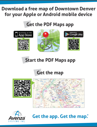
Imagine seeing such a sign on a hotel concierge desk, city tourist office or in an airport and how easy it would be to quickly obtain a map for that city.

Here is an example of how the City of Stavanger, Norway has employed a QR code on their city maps placed in popular and high foot-traffic areas.


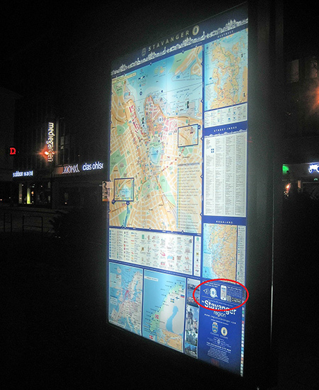
Photo and map courtesy of Stavanger Guide Maps Norway.
Notice the QR code in the lower right corner directing viewers to the Avenza Maps app.

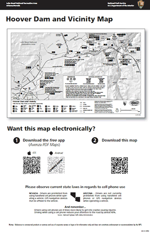
Lake Mead National Recreation Area has also implemented QR codes by adding them to posters placed in Visitor Centres and other strategic areas to allow visitors to get their hands on the park map before hitting the trails.

qrcode

What else can you do with QR codes and maps?

  • QR codes can be strategically placed on printed maps, signage, websites, advertising and anywhere else your maps are promoted.
  • They can be placed on a paper map product to offer a digital copy of the printed map to someone who buys the paper one.
  • They can be used in magazine and newspaper articles to offer a map for sale for a destination mentioned in the article. If a map is used in an article a QR code can be used to offer that map.
  • QR codes can be placed on websites to enable the purchase of a map that is shown and offered for sale on that website.
  • They can be used on maps and map signage, such as those in Stavanger or on a hiking trail head map sign, to offer the same map that someone may be looking at on the sign.
  • They can be used on signs on hotel concierge desks, travel agencies, airports and train stations and any other place where travels congregate.
  • The ideas one can come up with are endless and we encourage everyone reading this to explore and exploit the use of Avenza Maps QR codes in their sales and distribution tactics.

Georeference Any Map in MAPublisher 8.7 with the New Georeferencer Tool

The new MAPublisher 8.7 Georeferencer is a fast, easy, and accurate way to update your current unreferenced map collection or data to prepare it for PDF Maps or other digital formats.

The first step is to open your unreferenced document in Adobe Illustrator. If the document is a vector PDF it is often advantageous to rasterize the document and save it as a TIFF to avoid any conflicts with text.

Once the map is open, we can use the Map Locations tool to place reference points or Page Locations on our unreferenced map. It is recommended that known points, or points that are unlikely to move such as the intersections of road ways, are used as reference because these locations will be easily recognizable (as seen in the following steps). Tip: You will also want to zoom in as close as possible to the point to ensure the best possible accuracy.

Place MAP Locations

After we have given a name to our page location we will continue to place page locations until there is four or more spread as evenly across the map as possible. Having greater than four reference locations could help to improve the overall georeferencing accuracy.

Place MAP Locations

The next step is to find the real world counterparts, or World Locations, for each of our Page Locations using the Georeferencer tool. World locations can be sourced from an online map service, an open referenced document or entered manually. In this example we will use the built in Google Maps service to find our World Locations.

Place MAP Locations

The Google Maps option opens the Add World Locations dialog box. Choose a Page Location from the drop-down list and use the map to find the corresponding world location. Use the Google search bar and zoom buttons to zoom as close as possible to the corresponding world location. Place the cross hairs over the location, click, and confirm the world location with the page location.

Place MAP Locations

If the point is accurate, we will continue to add world locations for each page location. If not, the world location position can be changed by clicking and dragging it to a more accurate location. Right-click the pin to delete it.

If you’re unsure about the position of the original page location, you can drag the Add World Locations dialog box to the side and use the Zoom to artboard tool to help locate it.

After we have placed all of the World Locations with the corresponding Page Locations, we may now either specify a coordinate system (if one is already known) or click on Georeference and Save.

Place MAP Locations

After clicking Georeference and Save, a list of possible projections will be presented. Select the projection which most accurately represents your map. With each projection we see an associated error. This error is based on the combined accuracy of our Page and Map locations.

Place MAP Locations

As in this example, the first ranked projection is not always the best fit for our map, so it is best to use your best judgment when selecting a projection.

Click OK and add your map to a Map View and save. Your map is now referenced!

Place MAP Locations

We can check the accuracy of our georeferencing by zooming in closely to our Page (green) and Map (blue) locations. The further the distance between the two points, the less accurate a given georeferenced map is.

Place MAP Locations

You can also see a video of the Georeferencer in action on our YouTube Channel.

Sell Your Maps Digitally to Mobile Devices

As we have all seen over the last decade, the distribution and consumption of music, videos and books has moved to a digital model and so, the question then becomes, why not maps? Similarly to the aforementioned media types, maps are also very conducive to both the distribution and use in a digital and mobile way. As we see organizations like Borders, Blockbuster and Kodak succumb to this digital revolution, we map-makers must adapt or suffer a similar fate.

Many of you may be struggling with the issue of selling your maps digitally, tackling the question of the “mobilization” of your content and wondering how to attack the new markets.

But what if there were a generic iTunes/iBooks/Kindle type environment where a map publisher, like many of you reading this, could offer their maps for sale just like musicians and book publishers currently do with their songs and books? There is and it’s called the Avenza Map Store, accessible through the PDF Maps app.

Right now, the Avenza Map Store has more than 100,000 maps from publishers all over the world and we are looking for more as we strive to become the “iTunes of maps”. Map sales in January have already more than doubled December in terms of both units and dollars and December was higher than previous months already.

Signing up to become a map store vendor is free. We encourage and invite everyone to do so.

So here is the gist of the system and the thinking behind it.


What is PDF Maps?

The award winning PDF Maps app is an all-encompassing solution for the use, distribution, and sale of digital versions of paper maps to mobile devices. It includes both an app for users to use, discover and purchase maps directly using their devices as well as an in-app store to facilitate the transaction and delivery of the maps.

Think of it like iTunes, iBooks or Kindle, but for maps.

The app loads georeferenced maps and has functionality for locating (via GPS), measuring, plotting points, importing and exporting points and much more, this goes well beyond traditional paper map usage.


Why PDF Maps? What are the advantages?

The PDF Maps app and the connected map store responds to the demand of both map users and map producers for a 21st century digital map consumption and delivery solution. In an era where a vast amount of content is shifting from analog to digital delivery and use, the map industry demands a similar solution for its users and producers.

For the user it solves four major problems:

  1. How can I use a map I really like on my mobile device instead of the often less-desirable ones Google and other streaming services offer?
  2. Google and other streaming services fail to perform when there is no Internet connection such as when hiking or traveling in remote unconnected areas.
  3. Services that rely on a bandwidth connection are very undesirable when outside your home network area due to the high cost of data roaming charges.
  4. Google and other streaming services, as well as many existing mobile apps, do not always offer a useful map for a particular purpose such as hiking, boating, and visiting national parks which leaves much desire for a “better” map.


For publishers it responds to the following specific needs:

  1. With paper map sales declining, how can I get my content into the digital age for the mobile device market?
  2. Devices like Garmins, TomToms and in-car navigation systems are usually closed to outside map content and thus map producers cannot easily, if at all, make their maps available to users of these systems.
  3. In an effort to get into the digital marketplace it has to be easy, efficient, and inexpensive to repurpose existing content and map libraries. In most cases existing map libraries can be easily ported to the PDF Maps system and existing production processes do not need to be drastically modified, if at all, in order to produce new content for PDF Maps and the Avenza Map Store
  4. With digital map use there is no printing, production quantity guesswork, inventory to manage, distribution and returns to account for.
  5. Updates to the maps are controlled by the vendor and can be instantly made available to the marketplace, while at the same time, older redundant content can be instantly removed and discontinued.
  6. Immediate, easy and effortless entry into the digital map marketplace.


Available now for iOS. For more info visit PDF Maps site and the Avenza Map Store site.

Hope to see your content in the map store soon.

PDF Maps on Daily Planet [VIDEO]

[Video archived] Ted Florence provides a demonstration of the PDF Maps app for iPad. He compares a basic looking Google map of Algonquin Park to a very detailed map of the park which is available on the Avenza Map Store. Combined with using the built-in GPS, it provides a great offline navigation solution.

In addition to showing off the map, Mr. Florence loads a TTC map of Toronto and imports waypoints shared through email. This feature allows for collaboration between people who use the same maps. Importing and exporting waypoints can also be done through Dropbox or iTunes, as demonstrated here. Look for more sharing options in future releases.

PDF Maps is available on the App Store.

News Archive