My Account     Contact Us     Cart

Avenza Partners with Mapmobility to Provide Largest Database of Canadian Digital Maps for Mobile Device Users

Leading publisher of printed map products expands into digital world through PDF Maps app

TORONTO, (May 22, 2012) – Avenza Systems Inc., the leading developer of cartographic software –such as MAPublisher® for Adobe® Illustrator® and Geographic Imager® geospatial tools for Adobe Photoshop®– has partnered with Mapmobility, Canada’s most prominent producer of printed urban mapping products to announce the largest offering of Canadian digital maps for consumer use on the iOS platform. Avenza will host Mapmobility’s highly detailed maps in the PDF Maps app and digital map store providing a new way for mobile device users to access a rich resource of content that was previously only available in print. The PDF Maps app allows users to explore and navigate Canada without having to worry about losing reception due to cell tower proximity or high data roaming charges typical of other “streaming” map services, making it the ideal travel accessory.

Mapmobility holds the largest Canadian market share of printed map products with hundreds of atlas and folded map titles making the relationship with Avenza mutually beneficial for both companies and the consumer. The partnership enhances Avenza’s digital map database by adding more than 30 years-worth of Canadian cartographic content, while Mapmobility benefits from Avenza’s foothold in a digital marketplace to reach a new mobile map consumer with the PDF Maps app and Avenza Map store. Mapmobility has selected Avenza as its exclusive channel for selling and distributing digital versions of its maps making the Avenza PDF Maps app and store the only place to find the vast array of Mapmobility Canadian maps.

“Given the shift in how our audience has received their information in the last ten years, we wanted to focus on a hi-tech solution that allowed consumers to be more interactive with our detailed maps,” said Carl Nanders, Director of Business Strategy at Mapmobility. “What Avenza provided is a way into a digital retail space without having to recreate the wheel ourselves. Avenza’s Map store within the PDF Maps app provides a more meaningful way to reach an audience that has gone mobile which is extremely appealing to publishers who once relied solely on the paper product.”

Avenza’s PDF Maps app is an all-encompassing solution for the use, distribution and sale of digital versions of paper maps to mobile devices. It includes both an app for consumers to use, discover and purchase maps directly from their devices as well as an in-app store to facilitate the transaction and delivery of maps. The in-app marketplace provides a new mobile e-commerce venue that allows those in the industry to have access to more than 200 million Apple iOS users seeking information about specific maps.

“For years we’ve worked with publishers providing cartographic software to help create maps, but as consumers continue to change how they access and consume content, we’re delighted to be the conduit for the more than 130 map publishers, including Mapmobility, to deliver such detailed maps in a more interactive manner,” said Ted Florence, President of Avenza Systems Inc. “As we continue to strengthen our community of vendors, many companies are beginning to see how useful the PDF Maps app can be in introducing content to consumers and we’re excited to be a part of how the industry evolves in a digital age.”

The PDF Maps app takes advantage of geospatial technology that allows travelers to view and measure real world locations and attributes. Paired together with mobile devices that utilize GPS, such as an iPhone or iPad, the PDF Maps app provides constant access to geographic locations and even points of interest without the risk of losing reception due to cell tower proximity – making it the ultimate traveling accessory for those that are enthusiastic about travel or anywhere internet bandwidth is not available or is cost-prohibitive when roaming internationally.

PDF Maps is available now on the iTunes App Store free of charge for personal use. For more information about the app, visit the Avenza website at www.avenza.com/pdf-maps. Pricing of each map is set by the publisher and free maps remain free to users through the PDF Maps in-app map store.

More about Avenza Systems Inc.

Avenza Systems Inc. is an award-winning, privately held corporation that provides cartographers and GIS professionals with powerful software tools for making better maps. In addition to software offerings for Mac and Windows users, Avenza offers value-added data sets, product training and consulting services. For more information visit the Avenza website at www.avenza.com.

For further information contact:
Tel: 416-487-5116
Email: info@avenza.com
Web: www.avenza.com

New York-New Jersey Trail Conference Joins Avenza PDF Maps App Digital Map Store

– Regional conservation group now distributing its maps to mobile devices –

TORONTO, (May 7, 2012) – Avenza Systems Inc., producers of MAPublisher® cartographic software for Adobe® Illustrator® and Geographic Imager® geospatial tools for Adobe Photoshop®, announces that the New York-New Jersey Trail Conference has officially enrolled as a vendor in the Avenza Map Store, accessible through the award-winning PDF Maps app. In partnership with Avenza, the Trail Conference will make its popular series of over 50 hiking, trail and general recreation maps, covering a network of over 1,800 miles of public trails in the New York-New Jersey metropolitan region, available to recreationalists and adventurers for use on iPhones, iPads and iPod Touches.

“We are extremely delighted to have this well-known and time-honoured organization participate in the Avenza Map Store and are very excited to make their amazing series of maps available to mobile users,” said Ted Florence, President of Avenza Systems Inc. “The PDF Maps app is a great platform and many organizations are now seeing how easy it is to make their maps accessible to mobile consumers. We invite all map publishers to become a part of our vendor network.”

The PDF Maps app is an all-encompassing solution for the use, distribution and sale of digital versions of paper maps to mobile devices. It includes both an app for consumers to use, discover and purchase maps directly from their devices as well as an in-app store to facilitate the transaction and delivery of maps. Think of it as iTunes or iBooks for maps.

“This exciting use platform and distribution system for geo-referenced maps is perfect for putting our highly-detailed maps into the hands of our members for use on their mobile devices,” said Edward Goodell, Executive Director of the Trail Conference. “As more and more end users opt for and prefer to use maps on their mobile devices rather than paper it is essential that organizations like ours adopt powerful and cost-effective methods of delivering and using maps digitally. Avenza’s PDF Maps fits that bill.”

PDF Maps is available now on the iTunes App Store free of charge for personal use. For more information about the app, visit the Avenza website at www.avenza.com/pdf-maps. Pricing of each map is set by the publisher and many free maps can be downloaded at no cost through the PDF Maps in-app map store.

For more information on using The New York – New Jersey Trail Conference maps with Avenza PDF Maps visit http://www.nynjtc.org/pdfmaps.

More about Avenza Systems Inc.

Avenza Systems Inc. is an award-winning, privately held corporation that provides cartographers and GIS professionals with powerful software tools for making better maps. In addition to software offerings for Mac and Windows users, Avenza offers value-added data sets, product training and consulting services. For more information visit the Avenza website at www.avenza.com.

More about The New York – New Jersey Trail Conference

Since 1920, the New York-New Jersey Trail Conference has partnered with parks to create, protect, and promote a network of over 1,800 miles of public trails in the New York-New Jersey metropolitan region. The Trail Conference organizes volunteer service projects that keep these trails open, safe, and enjoyable for the public and publishes maps and books that guide public use of these trails. The Trail Conference is a nonprofit organization with a membership of 10,000 individuals and 100 clubs that have a combined membership of over 100,000 active, outdoor-loving people.

For further information contact:
Tel: 416-487-5116
Email: info@avenza.com
Web: www.avenza.com

Using QR Codes to Deliver Maps Electronically

Updated: August 6, 2015 – New URL syntax for QR codes

Delivering mobile maps just became even easier for Avenza Maps vendors. This is a brief overview of how vendors can easily create QR codes (Quick Response Codes) to help promote, sell, and deliver their maps electronically.

A QR code is a two-dimensional barcode that can be easily scanned using any modern mobile device. When scanned, the mobile device automatically launches a web browser to direct the user to a website or other action. In our case, the map product page (free or purchase) in the Avenza Map Store.

These QR codes can be strategically placed on printed maps, signage, websites, advertising and anywhere else your maps are promoted.

This is an example of such a QR code:

When scanned on a device that has Avenza Maps installed, this code will automatically launch the Avenza Map Store listing for Avenza’s Amsterdam map. From there, one can browse details about the map and immediately purchase it. In this case, the QR code contains a special URL to which only the Avenza Maps app will respond.


Create a QR Code to launch an Avenza Map Store product listing

Previously, two types of URL syntaxes—one each for Android and iOS—were used to create QR codes for map downloads. This is no longer the case. With the most recent update to the Avenza Map Store, only one URL syntax will be needed to create QR codes compatible for both Android and iOS.

The new URL syntax now shares the same link from the Avenza Maps site and will look like this: http://avenzamaps.com/maps/{mapsku} (e.g. http://avenzamaps.com/maps/62190). Adding a title to the URL is optional: http://avenzamaps.com/maps/{mapsku}/{title}. If a title is added, any spaces in the title should be replaced with dashes. For example, a map listing that has a SKU number of 61290 and a title of Amsterdam Netherlands will yield the URL http://avenzamaps.com/maps/62190/amsterdam-netherlands. To retrieve the URL of one of your maps, go to your Avenza Map Store vendor page, view one of your map listings and copy its URL.

Once you’ve retrieved the URL of one of your maps, simply go to one of the QR code generators recommended below:

https://qrcode.littleidiot.be
http://www.visualead.com/qurify2
http://createqrcode.appspot.com
http://qrcode.kaywa.com

Some sites provide an option to download the QR code in different formats. We recommend saving the QR code as a high resolution image or SVG.


Examples of QR codes to deliver maps from the Avenza Map Store

As described earlier, QR codes can be used with Avenza Maps to drive a map purchase, but they can also be used to effect the download of any map within the Avenza Map Store.

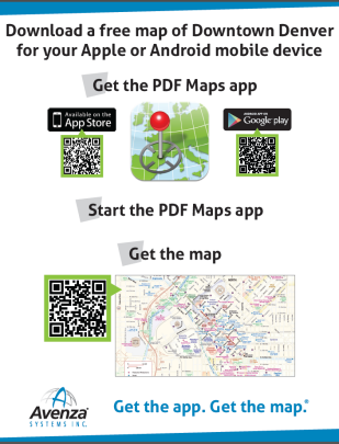
QR codes with the Avenza Map Store can be a very effective way to deliver a free map, such as those found in transit shelters, tourist offices, car rental counters, parks, and trail heads. In such cases, for example, a QR code can be placed on a transit map in a bus shelter or on a signpost at a trail head, and anyone equipped with the Avenza Maps app who may be looking at that map can scan the code and immediately get the map delivered to their device. Here is an example of such a sign Avenza used recently at an event in San Diego, CA.

Imagine seeing such a sign on a hotel concierge desk, city tourist office or in an airport and how easy it would be to quickly obtain a map for that city.

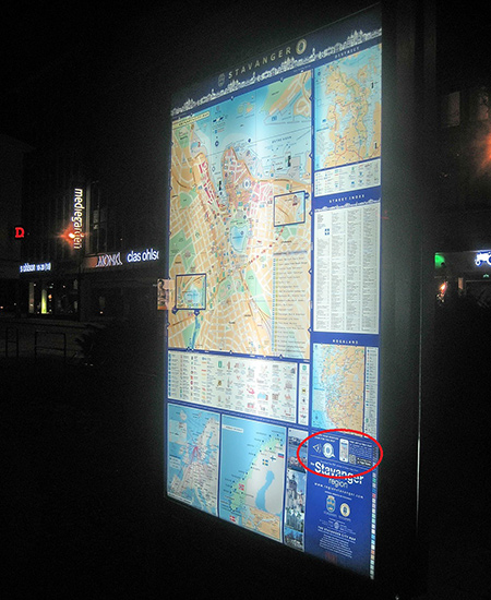
Here is an example of how the City of Stavanger, Norway has employed a QR code on their city maps placed in popular and high foot-traffic areas.


Photo and map courtesy of Stavanger Guide Maps Norway.
Notice the QR code in the lower right corner directing viewers to the Avenza Maps app.

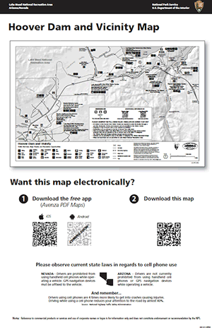
Lake Mead National Recreation Area has also implemented QR codes by adding them to posters placed in Visitor Centres and other strategic areas to allow visitors to get their hands on the park map before hitting the trails.

qrcode

What else can you do with QR codes and maps?

  • QR codes can be strategically placed on printed maps, signage, websites, advertising and anywhere else your maps are promoted.
  • They can be placed on a paper map product to offer a digital copy of the printed map to someone who buys the paper one.
  • They can be used in magazine and newspaper articles to offer a map for sale for a destination mentioned in the article. If a map is used in an article a QR code can be used to offer that map.
  • QR codes can be placed on websites to enable the purchase of a map that is shown and offered for sale on that website.
  • They can be used on maps and map signage, such as those in Stavanger or on a hiking trail head map sign, to offer the same map that someone may be looking at on the sign.
  • They can be used on signs on hotel concierge desks, travel agencies, airports and train stations and any other place where travels congregate.
  • The ideas one can come up with are endless and we encourage everyone reading this to explore and exploit the use of Avenza Maps QR codes in their sales and distribution tactics.

Georeference Any Map in MAPublisher 8.7 with the New Georeferencer Tool

The new MAPublisher 8.7 Georeferencer is a fast, easy, and accurate way to update your current unreferenced map collection or data to prepare it for PDF Maps or other digital formats.

The first step is to open your unreferenced document in Adobe Illustrator. If the document is a vector PDF it is often advantageous to rasterize the document and save it as a TIFF to avoid any conflicts with text.

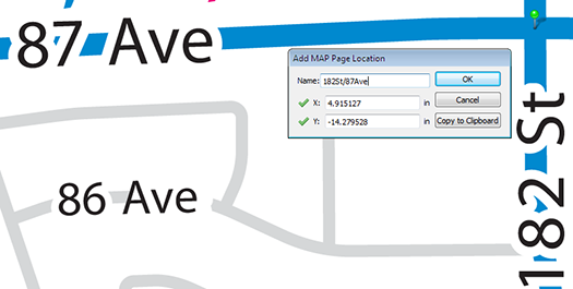
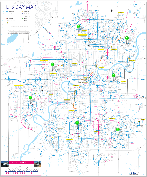
Once the map is open, we can use the Map Locations tool to place reference points or Page Locations on our unreferenced map. It is recommended that known points, or points that are unlikely to move such as the intersections of road ways, are used as reference because these locations will be easily recognizable (as seen in the following steps). Tip: You will also want to zoom in as close as possible to the point to ensure the best possible accuracy.

Place MAP Locations

After we have given a name to our page location we will continue to place page locations until there is four or more spread as evenly across the map as possible. Having greater than four reference locations could help to improve the overall georeferencing accuracy.

Place MAP Locations

The next step is to find the real world counterparts, or World Locations, for each of our Page Locations using the Georeferencer tool. World locations can be sourced from an online map service, an open referenced document or entered manually. In this example we will use the built in Google Maps service to find our World Locations.

Place MAP Locations

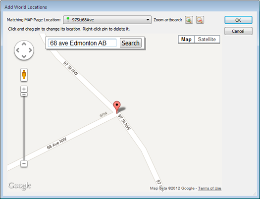
The Google Maps option opens the Add World Locations dialog box. Choose a Page Location from the drop-down list and use the map to find the corresponding world location. Use the Google search bar and zoom buttons to zoom as close as possible to the corresponding world location. Place the cross hairs over the location, click, and confirm the world location with the page location.

Place MAP Locations

If the point is accurate, we will continue to add world locations for each page location. If not, the world location position can be changed by clicking and dragging it to a more accurate location. Right-click the pin to delete it.

If you’re unsure about the position of the original page location, you can drag the Add World Locations dialog box to the side and use the Zoom to artboard tool to help locate it.

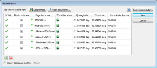
After we have placed all of the World Locations with the corresponding Page Locations, we may now either specify a coordinate system (if one is already known) or click on Georeference and Save.

Place MAP Locations

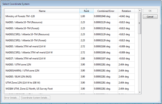
After clicking Georeference and Save, a list of possible projections will be presented. Select the projection which most accurately represents your map. With each projection we see an associated error. This error is based on the combined accuracy of our Page and Map locations.

Place MAP Locations

As in this example, the first ranked projection is not always the best fit for our map, so it is best to use your best judgment when selecting a projection.

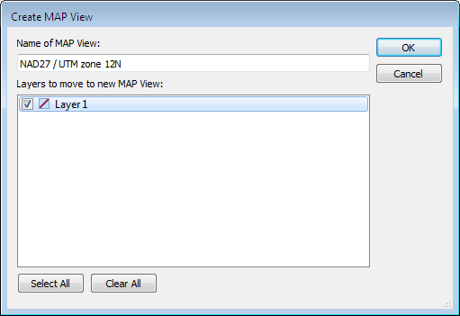
Click OK and add your map to a Map View and save. Your map is now referenced!

Place MAP Locations

We can check the accuracy of our georeferencing by zooming in closely to our Page (green) and Map (blue) locations. The further the distance between the two points, the less accurate a given georeferenced map is.

Place MAP Locations

You can also see a video of the Georeferencer in action on our YouTube Channel.

News Archive