My Account     Contact Us     Cart

Avenza Releases Geographic Imager 3.3 for Adobe Photoshop

– Newest release fully compatible with Adobe CS5.5 –

Toronto, ON, May 16, 2011 – Avenza Systems Inc., producers of MAPublisher® cartographic software for Adobe Illustrator® and PDF Maps for Apple iOS, is pleased to announce the release of Geographic Imager 3.3 for Adobe Photoshop. This release is fully compatible with Adobe Photoshop CS 5.1, which is also known as Adobe Photoshop 12.1 in Adobe CS5.5, as well as Adobe Photoshop 12.0.4 in Adobe CS5.

“We’re delighted to release Geographic Imager 3.3 to follow the latest update of the Adobe Creative Suite,” said Ted Florence, President of Avenza. “Our users will be happy to know that this release of Geographic Imager will be fully supported and compatible with Adobe Photoshop CS5.1 on both Windows and Mac. We’ve also included some priority fixes from user requests,” he added.

A greater number of new features are planned for the next release of Geographic Imager.

Additional Geographic Imager 3.3 features

  • Support for Adobe Photoshop CS5.1 (also known as Photoshop 12.1 in Adobe CS5.5) on Windows and Mac
  • Support for Adobe Photoshop 12.0.4 in Adobe CS5
  • New Pixel-as-Point preference option
  • New Create Single Layer option for Terrain Shader


More about Geographic Imager for Adobe Photoshop

Geographic Imager is powerful software for working with spatial imagery in Adobe Photoshop that leverages the superior image editing capabilities of this raster-based image-editing software and transforms it into a powerful spatial imagery editing tool. Work with satellite imagery, aerial photography, orthophotos, and DEMs in GeoTIFF and other major GIS image formats using Adobe Photoshop features such as transparencies, filters, and image adjustments while maintaining georeferencing and support for hundreds of coordinate systems and projections.

Geographic Imager 3.3 is available immediately free of charge to all Geographic Imager Maintenance Program members and at prices starting at US$319 for non-maintenance members.

More about Avenza Systems Inc.

Avenza Systems Inc. is an award-winning, privately held corporation that provides cartographers and GIS professionals with powerful software tools for making better maps. In addition to software offerings for Mac and Windows users, Avenza offers value-added data sets, product training and consulting services. Visit www.avenza.com for more details.

For further information contact:

Tel: 416-487-5116 ● Email: info@avenza.com ● Web: www.avenza.com

MAPublisher Dot Density Maps

Dot density themes are sometimes called dot distribution maps because they show where particular data characteristics occur. It uses dots or other symbols to represent the number of occurrences of a given data characteristic in a particular location. Starting at MAPublisher 8.4, the ability to create dot density maps is available through the provision of Dot Density Themes.

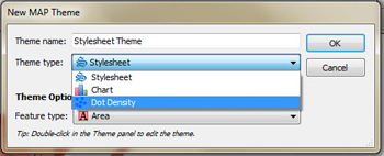
When creating a new MAP Theme simply choose “Dot Density” from the available theme types. The creation of a dot density theme is facilitated through the MAP Themes panel. The dot density theme is an Adobe Illustrator effect applied to an area layer.

Item 2: Coordinate system of the map

As dot density maps are most useful for showing where particular data occur, they may only be generated for MAP Area type layers. Most often, symbols are used to represent data occurring within a bounding polygon such as a census tract, zip code or county polygons.

Item 2: Coordinate system of the map

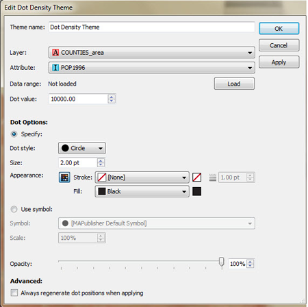
Dot density effects are created on a per layer basis, based on various user defined settings. Data ranges can be determined from selected attribute columns and then a dot value can be assigned a corresponding symbol at which point MAPublisher will map the appropriate results. Users may apply default symbols or load custom ones based on Illustrator symbol sets

In this example, population tallies per county have been loaded, assigned a dot value of 10,000 with a designated symbol of a 2pt black dot.

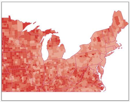
This screenshot displays the map prior to applying the dot density effect.

Item 2: Coordinate system of the map

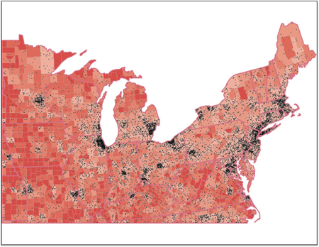
The screenshot below displays the map after having applied the Dot Density Theme using the parameters displayed within the dialog .

Item 2: Coordinate system of the map

Using Make Index for Geoprocessing in MAPublisher 8.4.2

New to the MAPublisher 8.4.2 Make Index tool is an enhancement that allows you to index objects relative to a MAP Area layer’s features instead of an index grid. This new functionality compliments the existing geoprocessing tools found in the Buffer Art tool and the Spatial Filter in the MAP Selections panel.

Item 2: Coordinate system of the map

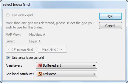
An index grid on a MAP Legend layer is no longer a prerequisite for using the Make Index tool. By choosing the “Use Area layer as grid” option in the Make Index dialog box, a spatial query will be performed and an index file will be produced based on the layer and attribute specified.

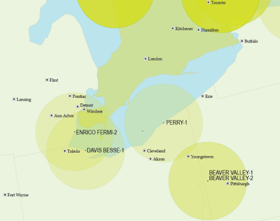
For this example, I have loaded a point file of cities and a point file of nuclear facilities against a background of North America. I then proceeded to use the Buffer art tool to create 80 kilometer buffers around each facility.

Item 2: Coordinate system of the map

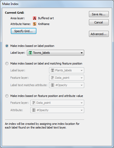
Finally, I will produce an index that returns which communities fall within the 80 km radius surrounding each nuclear facility. For this index I will choose my Towns_labels MAP Text layer.

Item 2: Coordinate system of the map

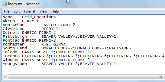
With these settings our index gives a line for each city that falls within the buffer, and after a tab delimiter, gives the name of each facility as found in the kmlName attribute of the Buffered Art layer. Notice that for cities that fall within the buffer of multiple nuclear facilities, the values from the kmlName attribute field are concatenated together with a semicolon “;”.

Item 2: Coordinate system of the map

If you choose to make an index using an index grid, the option to add an attribute from a bounding MAP Area layer can be accessed from the Advanced tab of the Make Index dialog.

News Archive