My Account     Contact Us     Cart

Faculty of Geo-Information Science and Earth Observation of the University of Twente (ITC) Chooses Avenza MAPublisher

Toronto, ON, March 26, 2010 – Avenza Systems Inc., producers of MAPublisher cartographic software for Adobe Illustrator and Geographic Imager spatial tools for Adobe Photoshop, is pleased to announce that one of the world’s foremost international professional education establishments in the field of geo-information science and earth observation, the Faculty of Geo-Information Science and Earth Observation (ITC) – formerly known as the International Institute of Geo-Information Science and Earth Observation – of the University of Twente in Enschede, the Netherlands, has extended multiple floating licenses of its MAPublisher software to be used in combination with Adobe Illustrator CS4.

Jeroen van den Worm, Lecturer Thematic Mapping and Inter-active (web) Map Design at ITC’s department of Geo-information Processing explains: “ITC has already been deploying MAPublisher since its 3.0 release in combination with former Macromedia Freehand graphic software. By extending the MAPublisher licenses to Adobe Illustrator, we can continue with offering our students a GIS based low-cost map design and production platform. It is an excellent complimentary solution to the other standard GIS software that is extensively applied by our faculty. Furthermore, the combination of Adobe Illustrator CS4 and MAPublisher 8.2 enables our cartography students to produce innovative and creative GIS based maps without having to worry about graphic output limitations. These maps can also be used in combination with other CS4 software such as Photoshop and Flash to create inter-active (web) map applications”.

“As many organizations in countries under development are facing limited financial budgets, we also apply the same mixture of GIS and graphic software in our joint education diploma courses in geoinformatics at the Ardhi University in Tanzania and the Ghana School of Survey and Mapping in Ghana”, he added.

More about MAPublisher

MAPublisher is powerful map production software for creating cartographic-quality maps from GIS data. Developed as a suite of plug-ins for Adobe Illustrator, MAPublisher leverages the superior graphics capabilities of this graphics design software for working with GIS data and producing high-quality maps with efficiency. Full details and downloadable demo versions are available at www.avenza.com.

More about Avenza Systems Inc.

Avenza Systems Inc. is an award-winning, privately held corporation that provides cartographers and GIS professionals with powerful software tools for making better maps. In addition to software offerings for Mac and Windows users, Avenza offers value-added data sets, product training and consulting services.   Visit www.avenza.com for more details.

More about Faculty of Geo-Information Science and Earth Observation of the University of Twente

The Faculty of Geo-Information Science and Earth Observation (ITC) of the University of Twente provides international postgraduate education, research and project services in the field of geo-information science and earth observation using remote sensing and GIS. The aim of ITC’s activities is the international exchange of knowledge, focusing on capacity building and institutional development in developing countries and emerging economies.

For further information:
Avenza Systems ● 416-487-5116 ● info@avenza.com ● www.avenza.com

Faculty of Geo-Information Science and Earth Observation of the University of Twente
Tel: 31-(0)53-487-4444
Email: info@itc.nl
Web: www.itc.nl

Import Geodatabase Feature Classes into Adobe Illustrator

In this post, we’ll cover how simple it is to import a geodatabase feature class into Adobe Illustrator using MAPublisher import tools enabled with the Spatial Database add-on.

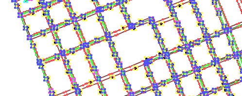
Imported features

Spatial databases are optimized data repositories for spatial data storage and management. Many GIS environments use spatial databases to easily access and manage GIS data in a central location.

MAPublisher 8.2 introduces support for import of the popular ESRI single-user and multi-user Geodatabases: Personal, File and ArcSDE Geodatabases; and direct access to ArcSDE server. The MAPublisher Spatial Database importer is built on ESRI software libraries and requires a valid ESRI software and license installed on the computer (ArcGIS 9.2 and higher).

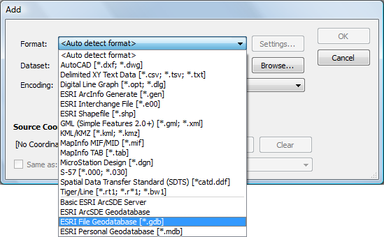
To import one, you can use either Simple Import or Advanced Import. In this scenario, we’ll use Advanced Import. When we add data, a list of Geodatabase types are located at the bottom of the Format list. We’ll be importing some feature classes from a simple geodatabase consisting of waterlines, hydrants and valves.

Add dialog box

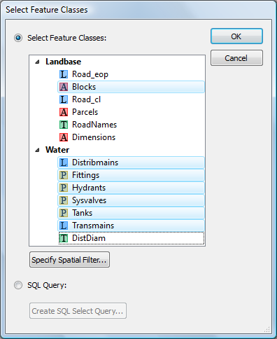
After browsing for the geodatabase (a File geodatabase in this case), the Select Feature Classes dialog box appears. We’ll go ahead and select a few feature classes from the Landbase and Water feature sets listed.

Select Feature Classes

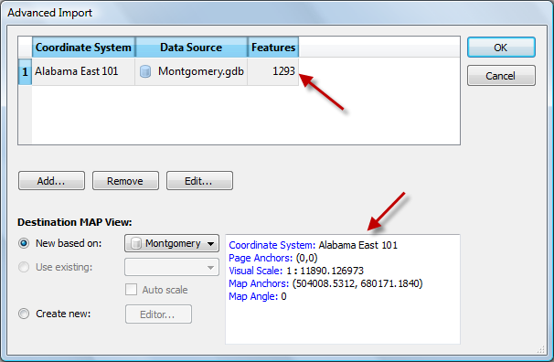
The Advanced Import dialog box shows the number of features being imported and the coordinate system as well as page and map anchors.

Confirm geodatabase import

The features are imported and are ready to be used in a map.

Imported features

Easy Transformations in MAPublisher

MAP Views are designed to provide an easy method of accessing settings for specifying and transforming coordinate systems, for editing scale and data placement on the page and for exporting to GIS formats. The MAP Views panel allows for merging Adobe Illustrator layers, georeferencing existing Adobe Illustrator artwork, changing multiple layer names, and reprojecting data on the fly.

That said, it’s possible to create multiple MAP Views that each contain a different projected coordinate system in a single map document. The MAP Views panel can be used to move Adobe Illustrator layers from one MAP View to another, enabling to reproject vector art quickly. Layers can be moved via drag-and-drop or with the new Switch MAP View button. This is useful when testing how a variety of projections may fit into your layout. It’s also useful for creating inset or key maps.

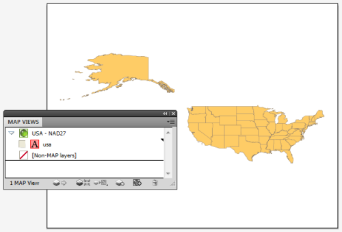
Here we have one MAP View called USA – NAD27. As the name of it implies, it is in a NAD27 projection. Let’s go ahead and make another MAP View so that we can perform an easy transformation.

USA in NAD27

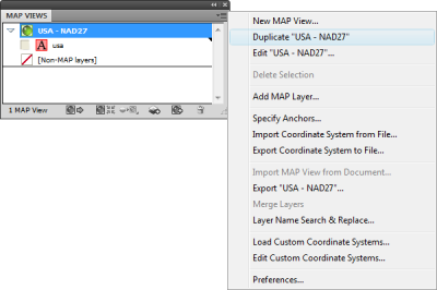
Click the USA – NAD27 MAP View to highlight it, then click the panel option menu (upper right corner) and click Duplicate “USA – NAD27”.

Duplicate MAP View

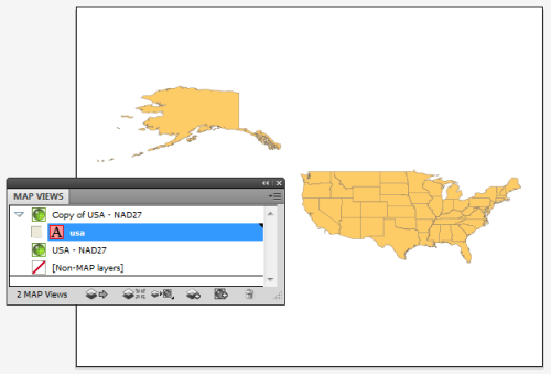
This creates a Copy of USA – NAD27 MAP View. Double-click the Copy of USA – NAD27 MAP View to edit it.

Copy MAP View

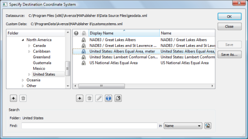
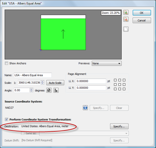
In the MAP View editor, change the title to USA – Albers Equal Area in the Name box. Below you can see that it is currently in NAD27. Check the Perform Coordinate System Transformation check box and click Specify. In the Specify Coordinate System dialog box, in the Folder list, navigate to Projected > North America > United States and click United States: Albers Equal Area, meter in the right-hand pane. Click OK.

Choose Albers Equal Area

Back in the MAP View editor box, you’ll see that the Destination is updated to show the United States: Albers Equal Area projection. Click OK.

MAP View editor

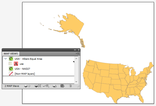
The map is reprojected from NAD27 to Albers Equal Area.

Albers Equal Area projection

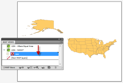
To reproject-on-the-fly by drag-and-drop, click the usa area layer and just drag it to the USA – NAD27 MAP View. Now you can switch back and forth between projections. You may want to duplicate the usa area layer in the Layers panel so that you can have two different projections at the same time. Remember to use the MAP View editor if you want to move a MAP view to retain spatial referencing.

Back to NAD27

To learn more about MAP Views, view Chapter 4 of the MAPublisher user guide.

News Archive